Friday, February 21, 2025

Pine View Campground (WI) Trails - Winter Paradise

Huge pines on the trail
Image - Steve Dawson
Thanks to a hike guided by Steve Dawson of the Blufflands Hiking group in mid-January, I was introduced to this great winter hiking trail. In the past month, I've returned with friends and family a number of times.

Located in Fort McCoy near Sparta WI, the Pine View is a popular and busy campground in the warm months of the year. 

But during the quiet times of the cold winter, the trails are nearly empty. And what is the draw in the winter? 

La Crosse River near it's source


The La Crosse River. It flows just behind the campsites between the trails  on the loop and creates a stunning hike in the bleakest times of winter. The source of the river is nearby and the waters - just the size of a healthy stream here - meander, creating a beautiful setting in a forest filled with giant pines and hardwoods. 


Trout Falls


The trout-filled river with its icy edges flows swiftly and features some rills and Trout Falls, a gorgeous small waterfall as well as crystal clear waters. The main trail is a 1.5 mile mostly flat loop trail perfect as a gentle amble hike or a regular hike. It is a delight in snowless cold months to have the river alongside as you hike the trail. It brightens those usual brown-and-buff snowless hiking days. And the towering pines add to the ambiance and glory of the trail.


One of many bridges

The first time I hiked this trail, I thought I HAVE to snowshoe this - it would be perfect. And indeed it is! When it snows, the trails are a snowshoer's dream. The river's icy edges contrast with the flowing water as you cross multiple bridges on the main loop trail. There are numerous spots to enjoy the river view along the way. The short length and flat terrain make it perfect for beginner snowshoers as well as vets.


There is enough dense brush and invasives along the river trail that it's hard to do off-trail snowshoeing. Further from the river, there are a few open areas to tramp that have a clearer understory. While I usually love a good off-trail tramp while snowshoeing, the trails here are pretty enough to satisfy me.


At the halfway point on the trail, you come to Trout Falls, which is clearly a very popular place in the summer. Beyond the falls, the river quietly pools and flows around some stunning rock formations. You have to fight through brush to see this but it is worth the effort.


There are additional trails that follow a disc golf course on the southwest side of the river that can add another mile or so to a snowshoe adventures as well. They can be slightly confusing beyond the main trails but that's why snow is nice. You can always easily follow your trail back. There are also little narrow, rough, alternative trails near the river that you can wander on.

Other than a rustic map at the trailhead near the main entrance, there aren't detailed maps of the hike. There is parking near Trout Falls that one can also use to access the trails as well. To the left is my AllTrails map from February 21.

Trout falls

This river trail loop will remain a go-to winter destination for me.  It's quiet forest beauty and close river views are refreshing during long snow-drought days of recent winters.  And during snowshoe treks, the snow blanketed forest and ice formations make a beautiful and easily snowshoed scene.


THE HIKE
A 1.5 mile loop trail on both sides of the narrow La Crosse River and under a canopy of massive mature pines and hardwoods make this mostly flat trail a jewel for easy winter hiking/snowshoeing. Multiple short bridges along the route add to the fun. Trout Falls at the halfway point is a high point. There are info kiosks along the trail highlighting the flora, fauna and terrain of the area.

La Crosse River
The Location
Don't trust your GPS on this one or you'll end up at Fort McCoy's front gates. These directions will get you to the trailhead: From Sparta, take Hwy 21 east until you see the large Pine View Campground sign. Turn there. Follow the road for 3/4 of a mile and turn right by the sign that says "White Tail Ridge". Follow that road until the yield sign at the end (ignore the sign you’ll see on this road that indicates a right hand turn to the campground). Turn left and follow the road .6 miles and take a right at the campground entrance. Immediately take a right again onto an unplowed campground road and follow it around until you see playground equipment with a basketball hoop on your right. Park by the net. Head west beyond the playground equipment and you will spot the trailhead!

At the foot of a BIG pine

Images, unless noted - Marge Loch-Wouters

Looking for more area hikes? Please stop by the web version of the blog and under the "Labels" tab on the right hand side of the blog, click on "find-a-hike". There are over 75 hike descriptions and lists of hikes to try!

Tuesday, February 18, 2025

What's Up with Area Blufflands Trails?

Image - Larry Sleznikow

As a member of La Crescent MN's Park and Recreation Commission as well as it's Natural Resources Advisory Group, I get to do some deep dives into efforts surrounding outdoor recreation in the the area. 

Just recently, The Blufflands Coalition, a group made up of local governments and local outdoor groups interested in recreation, conservation and restoration, released their 2024 Annual report. 

This group was created in response to The Blufflands Plan (2016), developed in 2016 by the La Crosse Area Planning Committee. The overall goals of the group: improved public health, ecological diversity, connected communities, economic strength, and a high quality of life. 

In La Crescent, we have a plan as well  - La Crescent Blufflands Plan (2017).

As a trail user, I believe it's important for all of us to be aware of progress involving our trails and the efforts that different members of the coalition are involved in. It is also important in terms of advocacy efforts, to know this information to do the best, most factual work in standing up for best use of trails. 

After a coalition of hikers worked hard to slow what seemed like a headlong rush a few years ago to make our already shared trails in La Crescent more bike friendly, these trail users continued to work within the community and its commissions and city council to make the case that we could continue to share the trails but not necessarily give priority to one trail user type over another.

So I am happy to see this kind of transparency to continue to help hikers stay in the loop and be part of decision-making.

If you see something in the 2024 report that you think is a positive for other hikers, or conversely, appears to be a negative, let the organization or municipality know. 

Our voices matter.

Friday, February 14, 2025

Naturalist's Corner - Let's Give a Little Love to Opossums


This month's Naturalist's Corner guest columnist Steph Hanna focuses on one of our more under-appreciated forest inhabitants - the opossum. Steph is the Community Program Manager Steph Hanna at the Nature Place in La Crosse WI. As an educator with over 30 years of experience, she believes education is the key to connecting people to nature. Stephanie earned a Bachelor of Science in Biology and a Bachelor of Education from the University of Saskatchewan. She worked as an elementary and middle school teacher in Canada before moving to the Driftless Area. She loves to learn and teach others. This recent article is reprinted with permission from The Nature Place's blog. 

Overly Overlooked Opossums
November 27, 2024
Stephanie Hanna | Community Programs Manager


Recently, I came across a very cute graphic of an opossum saying, “I don’t get rabies and I have nice little hands! I am the perfect mammal!” I chuckled to myself and was reminded how fond I am of this particular critter. It reminded me of a time a few years ago, when my dog suddenly let out the “alarm bark” towards our grill. Finally stooping down to pick her up, I glanced under the grill myself to see a very cute, young opossum hissing furiously at me. Wow, did she show me all of her very pointy teeth!

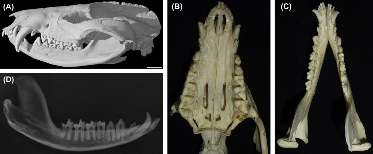
Opossums have a different set of teeth in comparison to other Northern American mammals. In total, they have 50 teeth, which include incisors, canines, and molars. The ten incisors, AKA the pointy teeth, are at the front of the mouth and behind those are canines, which are used to tear flesh. The remaining 36 molars located in the back of the mouth used to grind and crush food. According to a CritterStop article, the molars have a complex surface that allows opossums to efficiently break down plant material and small bones. Surprisingly, opossums can also replace their teeth. When a tooth falls out, a new one grows in its place! They are omnivorous and their teeth are adapted to the various items they eat. When threatened, they will hiss and bare their teeth as a warning.

Their teeth are not the only unique feature; they are the only marsupial on our continent, meaning their babies are born underdeveloped and carried in a pouch. They can carry up to 13 babies in their pouch, and when the joeys are too big to fit they cling to their mom’s back. Opossums also have an opposable thumb on their hind feet that helps them with climbing. The Nature of Things, Canada’s long-term nature show, says that “these misunderstood marsupials clean up our yards and even help fight Lyme disease.” This is due to their rapid consumption of the common carrier – deer ticks. One of these critters can eat 4,000 ticks a week!“
Source: https://www.sciencedirect.com/topics/agricultural-and-biological-sciences/opossum


An opossum’s superpower is that they digest just about anything including a dead animal’s bones and carcass. They are very helpful at decomposing dead organisms. Their other superpower is immunity to snake venom. The Nature of Things says that “they might hold the key to fighting snake bites around the world!” because of that.


The online article 12 Facts About Opossums: Truly Misunderstood Wild Animals by World Animal Protection says that the name “opossum” is derived from the Algonquin language. The Algonquin are First Nations people who now live in Eastern Canada, originally residing in Quebec, Ontario, Upper Michigan and Wisconsin. The word is derived from the Algonquin word “apasum” which means white animal.

In Wisconsin winters, opossums will spend most of the time in a den but often come out to look for food such as mice, rabbits, birds, and garbage. They are native to South America and have made their way into North America, so because they are not really adapted for winter their tails and ear tips sometimes freeze. The species found in the USA and Canada is the Virginia Opossum. Next time you see an opossum in the wild or your backyard, remember what amazing little creatures they – even if they have a face that some say only a parent could love!

Tuesday, February 11, 2025

Upper Hixon (WI) - Stinkys/Chicanery/Quarry Trails

Spotting a woodpecker
Image - Kris Lawson
One of my all-time favorite winter hikes is on the these wonderful twisty-turny shared hiking and biking trails in the Hixon Forest behind the NOAA radar (affectionately referred to by locals as the "weatherball"). Because it is an extremely popular biking trail, I love saving it for the cold, snowy weather when bikes are few and far between - and those that are there are grateful for our boots or snowshoes stamping the snow flatter.

The other reason that this is one of my favorite cold-weather hikes is that it hugs the bluffsides so you are often protected from bitter cold winds. What's not to love?  

Spotting MANY trails in "see-through season"


The trails, which switchback back and forth and up and down the rolling hills are narrow and few have the carved banks on the turns that steeper biking sections have. So hiking is really pleasant. In winter, you also get to see the many trails that are laid out in the snow as you ascend and descend. 


While you don't do this trail for many expansive views, you are surrounded by forested bluffsides and big views of the bluffsides in this "see-through" season.

City of La Crosse Map

From the Upper Hixon parking lot, you head down the trail by the Pump Track (3) for a quick left onto Prairie Loop (6) and then a right onto  Stinkys. You interrupt your Stinkys sojourn at Marker 35, take a brief left and head down a connector to turn left onto Chicanery (34) . Follow that up to where Quarry trail starts (15). This is a great turn-around spot for a 1.7 mile winter hike.

Spotting animal tracks - hello squirrels!
They hit the trails before we did.
On the return take, the trail spur off to the right (37) to cross a bridge over a ravine and then rejoin the trail and head back to the connector trail (34-35). Cross the trail and you will be back on Stinky's as you switchback up to the rim where you rejoin Prairie Loop by turning right at the connector (8) and right again on Prairie loop and voila! You're back.

If you want to do a longer hike, at Marker 15, take the Quarry trail to the Mississippi Valley Conservancy's Mathy Quarry trail system, a mile down the trail. If you go there to turn around, you will add an extra 2 miles out and back for 3.7 mile hike. This is an especially nice trail in non-winter months when wildflowers are in bloom and the trails are shaded.

THE HIKE
Shared hiking/biking trails snake up and down and around the bluffside forests. Bird life is abundant during warmer months as are flora and fungi. Winter is a great time to hike/snowshoe these trails when bike traffic is considerably less, although many weekdays work in warm weather when there are fewer bikers too. It's great to have a map app like AllTrails with you since there are a profusion of trails and junctions!

The Location - N2788 County Road FA - La Crosse, WI 54601
From La Crosse, head up Bliss Road east towards Grandad's Bluff. Keep left at the Alpine Inn at the top and drive about 1/2 mile to Cty FA on your left.  Turn right at the NOAA weather station by the radar "weatherball." There are three trailheads from this parking lot. You want to head to the trail between the weather ball and the Pump Track.


A perfectly crispy hike with friends
and away from the wind

                                            Images, unless noted - Marge Loch-Wouters

Looking for more area hikes? Please stop by the web version of the blog and under the "Labels" tab on the right hand side of the blog, click on "find-a-hike". There are over 75 hike descriptions and lists of hikes to try!


Friday, February 7, 2025

MN Driftless Hiking Trail Updates

When last we checked on what’s up with the development of the proposed MN Driftless Hiking Trail, they had just received a $400,000 grant through the MN voter-approved Environment and Natural Resources Trust Fund.*  These funds helped them hire a new trail director, Alexa Shapiro (founder of the Winona Outdoor Collaborative) and will fund trail building equipment and mapmaking for the trail over the next 2.5 years.

On January 17, the group released their first report on activities over the past few months since Alexa joined the group as Trail Director. Here are a few highlights:

"It’s been 90 days since we hired our first employee, and we’re proud of how much we’ve accomplished in just three months. While we’ve made significant progress, there is still a lot of work ahead to bring the Minnesota Driftless Hiking Trail to life. The past three months have been a whirlwind of activity and connection as we work toward establishing accessible trail in state forests, parks, and local areas. Here's a snapshot of what we've accomplished and where we're heading:

Trail Designation Progress
  • Met with the Department of Natural Resources (DNR) to kick off conversations about designating trails on public lands.
  • Initiated discussions with local city officials to understand the process for trail designation on city-owned properties.
Community Engagement
  • Hosted a community forum in Chatfield to gather input on the trail project. We heard valuable thoughts, ideas, and concerns that will help us build a trail aligned with the community’s vision.
  • Planned additional community forums in Caledonia and Whalen to ensure widespread input and engagement across the trail corridor.
Exploration and Outreach
  • Spent time hiking and exploring in the trail corridor, including Beaver Creek State Park, the Norwegian Ridge Birding and Nature Trail, and Cabbage Rocks, among others.
  • Met with board members and project advocates, strengthening our relationships with key supporters."

To read the full update, please stop here.

And if you are interested in learning more, mark your calendars for their next event: 

Monday, March 10, 5:00 - 7:00 p.m.
City of Caledonia Municipal Auditorium, 219 E. Main St

“Join us for an engaging evening to discuss the future of the Minnesota Driftless Hiking Trail! We’ll share updates on the trail’s development and provide an open space for your ideas, questions, and feedback. Whether you’re a passionate hiker, a local resident, or simply curious, your voice matters in shaping this exciting project. Refreshments will be served, and no registration is needed!

This event is designed for residents of Caledonia and the surrounding communities. Whether you are a landowner, outdoor enthusiast, local business owner, involved in tourism, or simply interested in learning more and sharing your perspective, we warmly invite you to attend. Feel free to bring a friend or colleague—everyone is welcome!


This project is supported by University of Minnesota's Empowering Small Minnesota Communities program, a statewide initiative aimed at strengthening small communities' projects and plans for resilient physical, social, and economic infrastructure through UMN partnerships.

This is the second event in a 3-part series—a perfect opportunity to connect with trail staff, dedicated volunteers, and other outdoor enthusiasts. Stay tuned for details about our upcoming session in Whalen! Don’t miss this chance to be part of the conversation and help bring the Minnesota Driftless Hiking Trail to life. See you there!”

If you are interested in this effort to create a 100+ mile hiking/backpacking trail across the Driftless region of MN, you can subscribe to the Minnesota Hiking Trails' newsletter here. These occasional newsletters are info packed and keep you in the know.

Additional posts on the Minnesota Driftless Hiking Trail:


* This fund, originally approved by referendum in 1991, received  an overwhelming 77% of MN voters support statewide in November 2024 elections. The vote amended the state's constitution until 2050 to continue using lottery proceeds for the purchase of land, construction of trails, environmental research, fish and wildlife habitat projects, clean water initiatives and more. This system, administered through the Legislative Citizen Commission on Minnesota Resources, recommends millions of dollars in grant money each fiscal year to fund projects that benefit hikes, bikers, hunters, fishers, campers, skiers and all Minnesotans who use the outdoors. You can read more about it here.

Tuesday, February 4, 2025

Eagles Bluff Park (MN)

Rock outcroppings
Red Apple Trail - Upper
I've always considered Eagle Bluffs, a city of La Crescent Park, my "backyard" bluff. I live just a short 15 minute walk from one of its trailheads. If I get antsy for an aerobic hike, there she is! I've been waiting to share this hike since last summer because there have been some great changes going on.

La Crescent was awarded a MN SHIP  (Statewide Health Improvement Partnership) grant to create trail maps of Eagles Bluff Park. The trail mapping work was completed in 2023 and the GPS trail data converted into digital trail maps by Map the Xperience, thanks to the SHIP grant. The Lion's Club of La Crescent then generously donated $10,00 from the Club's Trails and Parks Project Fund as a Lion's Club activity supporting outdoor community activities to see the project to completion.

City of La Crescent Facebook post
But it takes more than money to make this kind of work happen. It takes vision from the city (provided by city Sustainability Coordinator Jason Ludwigson), city crews, and a lot sweat equity and planning from Lion's Club volunteers*.  The Lion's Club funds supported the creation of large trail maps. Then this fall, city public works crews and multiple Lion's Club volunteers installed the following to make wayfinding a snap:
  • 5 large map signs and pedestal at trailheads and on top the bluff
  • 30 color-coded, aluminum trail markers
  • 20 directional aluminum trail signs on each of the bluff's six trails 
 

City of La Crescent Facebook post
Finally, much work was done to maintain the trails this year, with city crews and volunteers clearing brush, dead overhanging and fallen trees and an ongoing project to clear invasive red cedar from one of the dry bluff prairies at the top of the bluff. 

The most recent workday in November brought volunteers from the MN Driftless chapter of The Prairie Enthusiasts, the La Crescent Natural Resources Advisory Group and other volunteers to join city staff in a work day that continued earlier work to bring the southeast prairie gem back to its glory.

All of this is to say, if you haven't been to this park yet - or recently - put it on your calendar for 2025

Eagles Bluff Trail map.
Click here to access a clear copy
There are five main trails inside this park, plus one spur access trail that connects nearby Veteran's Park to one of Eagles Bluff's trailheads on Mcintosh Rd. East. (green trail on the bottom of the map). There is ample parking at Veteran's Park and this trail begins just north of the baseball diamond. 

This short .42 mile ravine trail winds below two La Crescent neighborhoods. A trail sign directs hikers left and up a short hill, then across a residential street to the eastern trailhead of Eagle's Bluff park. 


Mcintosh Road East Trailhead and Yellow Trail
The Mcintosh trail (yellow trail) is just over 3/4 miles long. There is street parking along this quiet road by the trailhead. The trail has a few significant steep spots along the climb to the rim (approx. 500 ft elevation gain). At the beginning of the hike, you are right along the neighboring houses until you start gaining that elevation. This is a quieter and less used trailhead but it's my favorite.

Rocks along the Mcintosh Trail


You pass through a large hardwood forest. During early spring, late fall and winter you can also see some rock formations here and there as you climb to the rim. Looking south and east, you also get some great views of the Mississippi River almost all the way along the higher portions of this trail. 


View from Table Rock overlook
Image - Kris Lawson
There are a couple of fun spots along this trail. One is a marked spur trail to the right as you ascend that takes you down to an overlook on the edge of the bluff with a great view of the Mississippi. Continuing back on the main trail, you soon come to Table Rock, a significant rock formation which affords a view of the Mississippi's main channel and the historic Swing Bridge that crosses it.   You finish this trail at the junction of the red and blue trails on the rim. 


There is one permanent trail closure along the way that hikers may note - and are asked to honor. The old Boy Scout, trail created and developed by the local scouts, is a heart-poundingly steep trail with few switchbacks. This trail has badly eroded over the years. While the community appreciates what the scouts built, the decision was made to close it.

Red Apple Drive Trailhead and Red Trail/Orange Trails
Red Apple Trail - Lower (red trail)
The trailhead sign, located opposite Old Hickory Park, directs you up the grass and prairie hillside on a old grassy road. You will see a sign as you leave the wide grassy road for the Upper Red Apple Trail (orange) but let's stay on the main trail for now. 

Red Apple Trail Lower with trail marker
The .65 mile Lower Red Apple trail winds 350 feet slowly up and above the neighborhood through a hardwood forest. There are numerous rocks along the switchback trails as you near the top. This trailhead appears to be more used of the two main trailheads, with just slightly wider trails on some portions. You get fantastic views of the forest and sloping bluffsides as you ascend.

On your way up, near the end, you run into the trail junction for the Upper Red Apple Trail (orange) to your left, followed shortly by another junction that brings you to the Ridge Rocks trail loop (black), also to your left. You can continue on to the ridge top, though, to access the two trail loops on top the bluff described below.

Red Apple Trail - Upper
(orange trail)
This very short .22 mile trail is what I like to think of as the escalator to get you quickly up or down from the bluff top. You can access it off the trailhead as you begin or from the blufftop, .1 miles down the Red Apple Trail-Lower. It is a must-hike from either direction for it's massive rock outcropping right next to the trail at its halfway point. This sandstone formation is a real treat! 


Ridge Trail Loops 
Ridge Rocks Trail (black trail)
You can access this trail from the Red Apple trail (red trail) or the Mcintosh trail (yellow trail).  This takes you on a .42 mile loop around the north rim of the bluff. There are some nice views from the trail and rock "sitting" shelf along the way. During summer months, this trail can have nettle overgrowth onto the path so consider long pants if the tail sides haven't been cleared back. At the end of this trail, you can join either the Mcintosh (yellow) or Red Apple Lower trail (red) which can take you back to the trail junctions.

Eagles Bluff Loop Trail (blue trail)
Southeast prairie overlook in summer
Again, this loop can be accessed from either the Red Apple Lower (red) or Mcintosh (yellow) trails. It is another .42 mile loop that takes you through a lovely maple forest along the rim to two dry bluff prairies at the top. The southwest facing overlook looks out over an old orchard area that has been developed into one of the city's newer neighborhoods along with parts of the rest of the community. You can also look across to Vetsch Park and Stoney Point from this vantage point. The southeast facing overlook provides views to the Mississippi, Blue Lake and the Wisconsin and Minnesota bluffs. This remnant prairie has been extensively worked on to restore it. Both overlooks have vibrant prairies with plenty of flowers and insect life in the summer.


THE HIKE
2.5 miles of shared, narrow, primarily dirt hiking /biking trails (although hikers and runners are more prevalent) lead up from two trailheads to ridge trails and some fine forests, views, prairies and rock formations. The elevation gain is 350-500 feet (the Red Apple Dr trailhead starts slightly higher up the bluff). This is a good aerobic bluff hike that makes up for overall short mileages. Well-marked and maintained trails make this attractive in all seasons. This can be fun as a through-hike or as an out-and-back from any trailhead.

The Location
Red Apple Trailhead is opposite La Crescent MN's Old Hickory Park (422 Red Apple Drive) on the park's east side. 
Mcintosh Trailhead can be accessed from La Crescent's Veteran's Park (595 Veterans Parkway) located behind the Best Western Plus Hotel OR by on McIntosh Road East opposite houses at 165 and 163 McIntosh Rd E.


New trail signage and markers along the trail
* A big shout out to the Lion's Club of La Crescent for their generous donations of funds, time, planning, installation and continued support of the project. Lion's involved in the project: Stephen Gund, Randy Rosenberg Patti Martell, Curt Murray, Heidi Kerska, Teresa O'Donnell Ebner. 

The community and trail users can't thank you enough!


Images, unless noted - Marge Loch-Wouters

Looking for more area hikes? Please stop by the web version of the blog and under the "Labels" tab on the right hand side of the blog, click on "find-a-hike". There are over 75 hike descriptions and lists of hikes to try!

Saturday, February 1, 2025

I Spy on the Trails - January 2025

River birch in 58F sun, 1/30/25,
in La Crescent MN
Brrr! January came in with quite the nippy temps this year (negative temps and single digit temps) before spiking temps into the 30s - and then back down and up and down and up again. These head-whipping, roller coaster temperatures kept everyone guessing on what any day might bring throughout the month. Our final week brought on high 30s into the 40s (and finally breaking an all-time record for our area in January at 58F on Thursday, January 30) for significant thawing.

The Driftless Area was also in a January snow drought so, during hikes, we were mostly surrounded by brown. Luckily, Iowasota’s recent blog by Linda Haugen reminds us of the beauty we can find even on snowless trails.

La Crosse River at Pine View trails
Fort Mc Coy
Our quest to find snowshoe-depth snow near upper Michigan and up on the North Shore in early January came up empty.  I can report that these areas are now experiencing some welcome snowfall and silent sports enthusiasts are once more finding snow to play in.

Snow-lover though I am, I still found plenty of great places to hike and beauty on the trails. I was out on almost all of the days that weren't sub-zero with friends or family marveling at everything from wildlife to patterns in nature. Never give up, never surrender!


Here are a few of the highlights from January trails:


Great Grey owl near Grand Marais MN

Frozen waterfall near Grand Marais MN


Happy little pincushion moss, Fort McCoy WI


Fascinating layered knothole, Hixon Forest WI


Wood fern, Afterglow Lake, WI

Doe, La Crescent MN


Leaves on the trail, Eagles Bluff, La Crescent MN

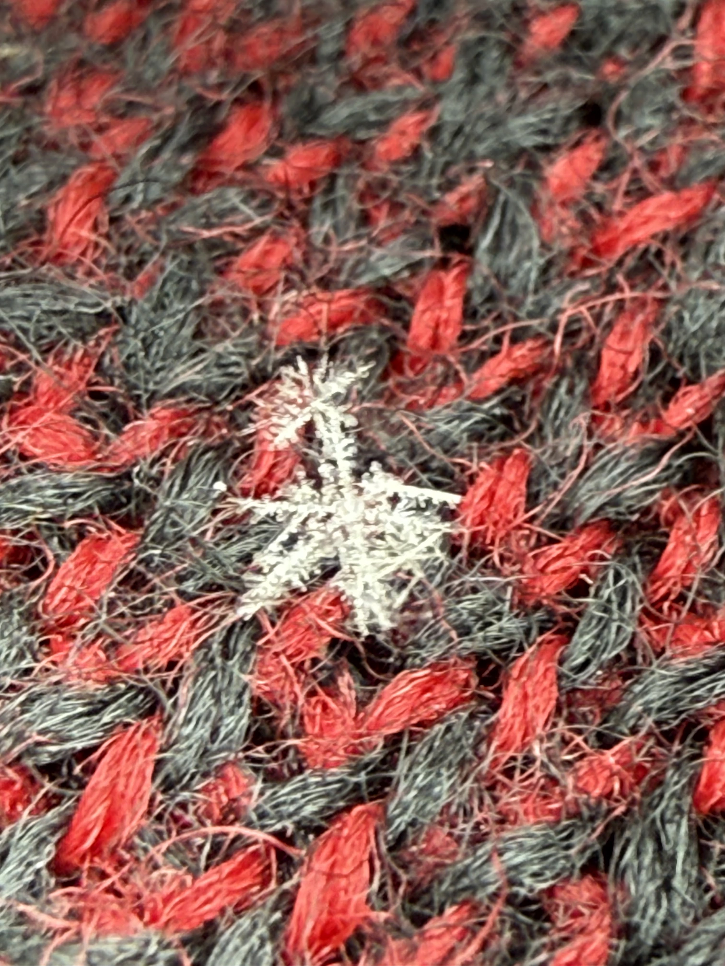
First day hike snowflake on my mitten
Eagles Bluff, La Crescent MN

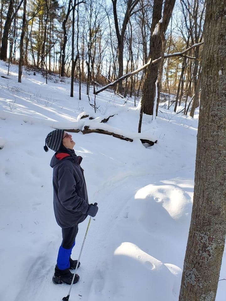
Sunshine on a snapping cold day
Pine View Campground, Fort McCoy WI
Image - Steve Dawson

What are YOU seeing on your hikes?

A month of hikes
Hikes below in colored, bold type or underlined have links to previous posts OR descriptions/location of the trails found online.

Eagles Bluff Park, La Crescent MN (2); Afterglow Lake trails, Phelps WI (3); Poplar River Lakeshore Trail, Lutsen MN; Devil’s Track SHT segment, Grand Marais, MN; Gitchee Gami State Trail, Grand Marais, MN; Bluffside Park, Winona MN (2); Hixon Forest, La Crosse, WI; Pine View campground trails, Sparta WI (2); Riverside Park/Gardens/Marsh Trails (2), La Crosse WI; Mathy Quarry trails, La Crosse WI; Reno Spillway, Reno MN; Wagon Wheel Trail, La Crescent MN; USFWS National Refuge Pool 8 Hwy 26 Root River trail, La Crescent MN

A new-to-me lookout, thanks to friends!
Image - Kris Lawson

The "I Spy on the Trails" column is a phenology (the study of seasonal changes in plants and animals) journal to chronicle year-round the weather, plant life and wildlife I observe while hiking. It is very useful in helping me compare observations from year-to-year. The column is published monthly from September through April and then twice-a-month from May through August when warm weather brings the natural world back to vibrant life.  

Images, unless noted  - Marge Loch-Wouters