Showing posts with label fossils. Show all posts

Monday, April 7, 2025

Whitewater Canyon Wildlife Area (IA) Lost Canyon Trail

I recently explored the Lost Canyon -Valley of 13 Caves Trail in the Whitewater Canyon Wildlife area on a hike sponsored by the She Explores Driftless Facebook hiking group. This Dubuque IA-based group was started by naturalists who wanted to hike for fun outside their jobs.  They share their passion for the outdoors and encourage women to build confidence in going out, exploring and creating friendships. 

This hike and group sounded right up my alley.  And who wouldn't want to hike through an area called the Lost Canyon and explore the Valley of 13 Caves?!? 

Dubuque and Jones Counties Conservation Boards cooperatively manage the Whitewater Canyon Wildlife Area. Over 500 acres are contained in the area with a number of designated trails. Hunting, hiking, angling, paddling and winter silent sports are all welcome in the wildlife area.

Our hike was described as: "2 miles on uneven hiking trails and hiking off trail on rocky & steep hillsides to access caves along the trail. Some caves are large enough to stand in, while some caves (for our adventure-seekers) require crawling. Wear sturdy shoes, a headlamp, and clothing that can get dirty." Sign me up!

Limestone cliffs
I arrived at the Whitewater Canyon Area trailhead near Dubuque in Bernard IA. There I met group of about 20 women from the greater Dubuque area (and some even further) who were raring to go on our cave-finding adventure.  

The 2.5 mile Lost Canyon trail (which includes the Valley of 13 Caves) follows a wide grassy path through a huge prairie area before it begins to descend into Lost Canyon. As soon as you start your descent, you see huge limestone rock formations on both sides of the now wooded hills. As we went further along the trail these formations towered over us and multiple caves could be seen up the steep hillsides. 

Small stalactites
Along the way, we were guided by naturalist Taylor Schaefers who shared plant identification, geology and history of the area in a conversational back-and-forth. Who knew that the Kentucky coffee trees we were seeing were initially planted by indigenous people near their dwellings and used for medicinal, recreational and spiritual practices. We do now! 

The hike itself was at a mellow pace and people could choose the level of challenge they were most comfortable with. I can only describe it as joyful. 
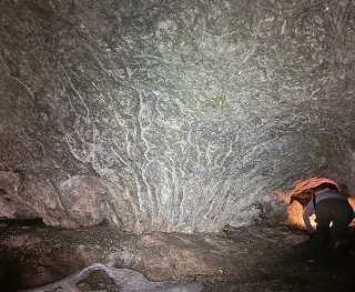

Cave bacon next to an explorer
heading into another chamber
As to the caves, they were 100% worth the drive. While we didn't explore all 13 (and no doubt more) caves, we took time to explore five or six. Most of these were large enough to stand up in. Some featured large openings, others we squeezed under low openings before we stood up. For the more adventurous, often the caves had small openings on the sides or in back that revealed narrow chambers to crawl in and explore further.


Fossil in the cave wall


Some of the caves were dry, others featured continuous dripping water from the ceiling and walls that creates tiny, calcified stalagmites, stalactites and cave bacon. 

With our headlamps, we could also explore the walls and ceilings, looking for marine fossils embedded in the limestone. At one time, this area, like ours, was undersea. Limestone holds a rich fossil record of trilobites, shells, cephalopods and receptaculites.


Baby bloodroot
Because I was 100 miles south of my stomping grounds, I was delighted to see many early wild ephemerals that are nowhere near bloom -or sprout- time here in the La Crescent area. Spring beauties (their leaves are edible!); sharplobe and roundlobe hepatica; just about bloomed Dutchman’s Breeches; and a tiny delicate bloodroot made their appearance. 

Walking Fern

I spotted purple-margined liverwort and fern moss and was also introduced to a new-to-me fern: the walking fern. My eyes were bedazzled by this young growth after so many brown months.


After the hike at a nearby taproom, some of us gathered. Laughs, conversation and many ideas for hikes in the area were shared. Thanks Taylor, Andrea, Diana, Megan, Emily and others for all the ideas.


THE HIKE

From it's start on top the prairie, this grassy, 2.5 mile loop trail descends 250 feet into a wooded valley with huge limestone walls and tumbled rocks. On each side of the wide fairly flat trail, the steep hillsides climb towards multiple caves which are open to exploration. There are a few faint paths to follow up to them. A headlamp or flashlight reveals many calcified (and growing) formations like stalactites and stalagmites as well as embedded fossils in ceilings and walls. A last short, steep hill brings you out of the woods and back to a prairie with expansive views of the countryside and back to the trailhead. 

The Location    29912 9th Avenue, Bernard, IA 
25 miles southwest of Dubuque off Hwy 151, head south on Curoe Rd. Follow the park signage until you see a last sign indicating a right turn at the entrance. Follow the gravel road to the large parking lot. There is a pit toilet available. The Lost Canyon trail is marked and begins to the south of the parking lot kiosk.

She Explores Driftless hikers

Looking for more area hikes? Please stop by the web version of the blog and under the "Labels" tab on the right hand side of the blog, click on "find-a-hike". There are over 75 hike descriptions and lists of hikes to try!
Wednesday, June 28, 2023

Whitewater State Park (MN) Hike/Amble

I recently enjoyed a great summer amble/hike along the Trout Run Trail in Whitewater State Park near Altura MN.  Ambles are on flatter trails, usually at or under 2.5 miles. The goal is to find wonderful hiking spots in nature where people who prefer a slower pace or are rehabbing from illness or injury can still get up close to nature.

Whitewater River where Trout Creek runs in

The  2 mile out-and-back trail runs next to the middle branch of the Whitewater River and then turns to follow Trout Run Creek through for the rest of the hike.  The trailhead is in the South Picnic grounds at the site of a former German POW camp that became a CCC camp. Much of the stonework seen in buildings, bridges and signs were built by CCC workers who quarried limestone from quarry at trailsend to build the park structures. A tornado destroyed the structures 70 years ago and the area became the south Picnic grounds.


"Corduroy" (logs) on the trail


Like many wetland tails, these trails often are damp, can be muddy after a rain, and are very brushy. There are small parts of the trail that are permanently damp and squishy and had "corduroy" laid down. This dampness also means lush growth into the trails narrowing them considerably during the summer. I always recommend long pants even on warm days because the prolific wetland plants - and nettles - crowd the trail and often overgrow it. 

The trail wound along past an abandoned beaver pond that now hosts a new population of frogs from elsewhere in the park. Bridges of various types cross back and forth over the spring-fed stream and you pass through hardwoods, floodplain forest and the end up in the meadow of the quarry.

Hackberry Emperor butterfly hitched a ride


On our hike we saw swarms of butterflies, skippers and dragonflies on plants, on seeps, near and over the water. It made a fun day of looking and identifying them.

What I love about Whitewater is that it has great trails for every ability. There is another Amble-worthy walk on the Meadow Loop in a restored prairie south of the visitor's Center. For those who like challenging climbs, the narrow valley offers a number of options that give you great bluff hikes and even greater views. Therese trails include the 4.2 mile Dakota Trail which takes you up to Eagle Point; Coyote trail at 2.7 miles; and Chimney Point to Inspiration Point at 2.2 miles.


The Dakota Trail which has the Eagle Point Lookout has stromatalite fossils that  you walk right over when you are at the top of the lookout. The circles on the photo to the left are fossilized stromatalites on the trail! The Driftless area was once under a sea (and actually near the equator!). Seeing those fossils as you walk gives you a real sense of the expanse of time.


This park has alot of history surrounded it including tales of how early settlers lost the soil during repeated flooding when prairies with their deep-rooted plants to hold the soil were replaced with shallow-rooted corn and soybeans. The Visitor Center has a graphic (left) on the floor that compares long-rooted prairie plants on the left with short-rooted agricultural plants on the right that replaced them. 

The river became flooded with the lost soil and silted up causing multiple damaging floods each year. Eventually most of the homes and farms lost their value and people left. What was left of the town of Beaver was purchased by the state and made part of a restoration of prairie in the State Park and the nearby Whitewater WMA (Wildlife Management Area).

Richard J. Dorer's grave


We ended our hike at the small Beaver Cemetery where we found the grave of Richard J. Dorer. If you are familiar with maps of southeast MN in particular you often see the name of  "Richard J. Dorer hardwood forest" scattered across the forest and bluffland. He died fifty years ago and his rustic marker gives you a sense of his love of the land and his commitment to conservation. He was a main proponent and mover of the restoration of Whitewater Valley. You can read a bit more about him here, here and here.


THE HIKE
An easy in-and-out 2 mile trail that follows the creek through wetlands, forest, floodplain forest and ends in a meadow at the quarry. Great birding and wildlife along the way. A spur to climb up to Inspiration Point is on the trail for those who want to head up. This park has alot of history and the Visitor Center is a must to learn some of it. Other trails that climb up the steep valley walls make this a great destination for those who want mellow tails and/or challenging trails.

Location: 19041 MN-74, Altura, MN 55910
If you head into the park from the south, you can find the Trout Run Trail beyond the Nature Store parking lot on a road that goes to the South Picnic grounds. Other trails start at the Visitor's Center, North Picnic grounds and near the group camp.
Great spangled fritillary

Additional posts about Whitewater State Park trails:

Images, unless noted - Marge Loch-Wouters

Looking for more area hikes? Please stop by the web version of the blog and under the "Labels" tab on the right hand side of the blog, click on "find-a-hike". There are over 75 hike descriptions and lists of hikes to try!