Showing posts with label spring hikes. Show all posts

Wednesday, May 7, 2025

Dodge County (WI) Ledge Park Trail


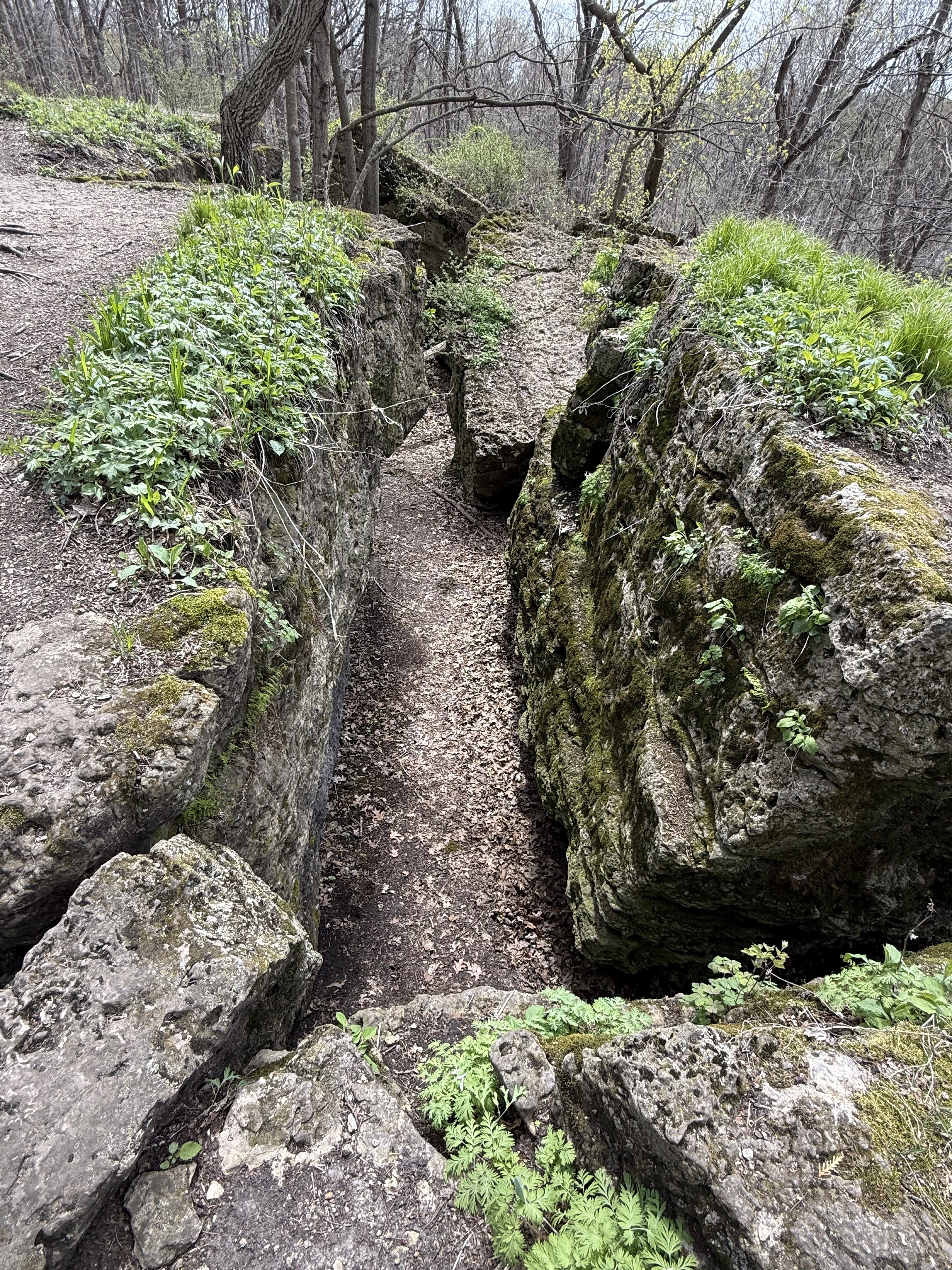
Recently, in a post on the Women Hiking WI Facebook page, I was intrigued by a wonderful gem of a hike in east central WI at a small county park between Horicon and Mayville. The video that was shared showed tumbled slabs of rocks, stairways and slots among high rock walls. Oooh.


Since I was heading to a conference in Oshkosh, I thought that exploring that spot on my way would be a perfect break before the serious business of the conference.


Ledge Park is well-named. It is part of a geological formation called the Niagara Escarpment. This arcing limestone formation originates in Canada, just under Lake Ontario curves upwards through Canada into Upper Michigan before descending through Wisconsin's Door County Peninsula before ending in the east central part of that state. While other portions of softer surrounding rock eroded over millions of years, this spine of dolomite endured to create a system of dramatic ledges.
Image - Wikipedia
This particular part of the escarpment has hiking trails on top the ledge. I chose the main trail, a one mile long trail (the red trail on this map) as my main trail. It follows along the rim but for the first half mile or so also has stone and wooden steps that lead to winding trails through a jumble of limestone slots and tumbled rocks under the rim. Pair that with an absolute riot of spring ephemerals in May and you have one of the most beautiful and fun exploratory hikes in Wisconsin.


The paths below the rim are a rock scrambler's dream. There are a few places to descend to a wonderland of narrow labyrinthian trails. They take you in and out of tight spots, climbing over boulders and through slots that lead to dead ends or narrow twisty passage. You won't put on miles but you can spend a long time playing around in the complex off the main trail.


If you ascend back up to the rim, you can hop between the tops of dolomite columns or cross a few by wooden bridges. The trail continues through the woods and behind a long series of campsites on the rim top to extraordinary views of the surrounding area including the massive Horicon marsh. 


While I was there on the last day of April, I was surrounded both on the rim and among the lower trails by carpets of Dutchman’s breeches, bellwort, wild ginger, bloodroot, sharplobed hepatica, spring beauty, trout lily, white trillium, violet, false rue anemone, bulbet bladderfern, ramp. By the time you read this, endless shooting stars will be blooming.

I can't recommend this fun spring hike enough. I thank Dineo Dowd for highlighting it and encouraging people to hike it!

THE HIKE
This 2 mile out-and-back hike runs along the rim of a dramatic ledge as well as down below the rim. The rim hike has outstanding views as you traverse some of the ledge columns. For those who like to scramble and explore, stone and wood steps lead you down below the rim to tumbled limestone rocks and slots in a series of short trails. For an added bonus, plan your hike in late April/early May and enjoy massive spring ephemeral blooms.

The Location - N7403 Park Road Horicon, WI, 43˚ 27.706’ N 88˚ 34.875’ W
Located approximately 3 miles northeast of Horicon off Raasch Hill Rd. Follow the park signs to turn onto Park Drive and then a leaft into the park. Park at the first parking lot and hit the trail! 

Trout lilies


Images, unless noted - Marge Loch -Wouters

Looking for more area hikes? Please stop by the web version of the blog and under the "Labels" tab on the right hand side of the blog, click on "find-a-hike". There are over 75 hike descriptions and lists of hikes to try!

Tuesday, March 25, 2025

Gearing Up for Spring Ephemeral Season - Part 1

Pasque flowers
Holland Sand Prairie
The sight of a skunk cabbage or Pasque flower heralds the beginning of spring ephemerals season. With the first Pasque flowers poking their heads up today, the season of delicate, spring wildflowers is just beginning. I can hardly wait.

While you can find spring ephemerals in any forested area or on the prairies, I have some favorite spots I like to go that are prolific nurturers of early wildflowers. If you are looking for fun (and sometimes challenging) hikes in the Driftless with big ephemeral rewards, try some of the hikes below. Click on the titles for a link to a more detailed description of hikes/locations.

In Part 2, we'll look at some spring gear to make your time in the ticky spring woods go smoothly. 

MINNESOTA

Dutchman's Breeches
Beaver Creek Valley SP

Great River Bluffs State Park 43605 Kipp Drive, Winona (off Hwy 90)
East Overlook and ridge trail along the road to the campground is moderate for elevation gains and has many early spring ephemeral wildflowers and Mississippi views. Kings Bluff trail rewards you with wildflowers along the trail and expansive prairie and stunning views of the Mississippi at its end Approximately 1.5 miles on out and back for each. Pit toilets and well-marked trails. Park map


Beaver Creek Valley State Park, 15954 County 1, Caledonia
Cross the bridge and look for the trail marker for Switchback Trail. Cross the creek and head steeply upward through a succession of amazing ephemerals. This trail is challenging but worth it. Or continue past this trailhead and stay on the main trail through the valley on an easy flat trail next to the trout stream (filled with native wild trout) for approximately 2-3 miles on grass trails (can be out and back or use loops to return). A hidden gem. Park Map

Shooting Star
Vetsch Park's Stoney Point

Vetsch Park, 722 N. 2nd St, La Crescent 
This park’s trails can be confusing. The lower slopes past the pollinator gardens by the parking lot are full of ephemerals. But, if you can find your way to Stoney Point (admittedly a challenge!), the early ephemerals are stunning. Ruth Nissan and Betsy Knowles, two La Crescent naturalists created a guide to the wildflower guide that is mounted on the city website. Can you find them all?


Wisconsin
Holland Sand Prairie, W7781 County Road MH, Holmen
Fairly flat with some rolling hills on grass/dirt trails for views of a beautiful sand prairie with abundant wildlife and wildflowers. There is a 1.3 mile boundary trail and a shorter .5 mile trail through the center of the property. Mississippi Valley Conservancy Map 

Perrot State Park  W26247 Sullivan Rd., Trempealeau, WI
Local hiker Sue Knopf recommends that hikers look "from somewhat beneath the little shelter (below where most of the wooden steps stop) to the park road which is filled with shooting stars, Dutchman’s breeches, wild ginger, and anemones, and then when you get to what I call the gorge, if you’re there at the right time (end of April, beginning of May depending on the year) the rock walls are filled with trillium, yellow bellwort, ferns, and more." Also recommended is the Riverview trail at the park!

Wild Ginger blossom
Sugar Creek Bluff

Sugar Creek Bluff State Natural Area, N. Buck Creek Road, Ferryville
You’re almost on the blufftop of this beautiful mixed savannah/oak prairie and mixed hardwood trail (1.5 miles out and back) that leads through an ephemeral-filled forest and out to beautiful prairie with great high views of the Mississippi River and MN/IA bluffs. There are slight elevation gains on this grass and dirt trail. Mississippi Valley Conservancy Map

Bluebells
Duck Egg Park


Duck Egg Park, Vernon County, Irish Road
The spring ephemerals along these trails are stunning - profuse and varied. Worth the sweat on the steep trail at the Upper Trailhead and just as good along the flat streamside trail accessed at the Lower Trailhead. Forest Map


IOWA
 
Maidenhair Fern Fiddlehead
Yellow River State Forest

Yellow River Forest Paint Rock Unit, Hwy 364 Mississippi River trailhead
This trailhead takes you steeply up 300 feet along a steep ravine festooned with spring ephemerals  (some at eye level). The rim trails are also great for spotting spring flora. It is a stunning display in May. Forest Unit Map . Also recommended by Sue Knopf, an avid local hiker, is another Yellow River unit, the Paint Creek unit which has carpets of bluebells and other wildflowers in the lovely forested lowlands near the park office.


And here is the second post in this series suggesting gear and insect protection.


Thigh-high Jack-in-the-Pulpit (to the  right)
Image - Mike Bonner

Images, unless noted - Marge Loch-Wouters

Looking for more area hikes? Please stop by the web version of the blog and under the "Labels" tab on the right hand side of the blog, click on "find-a-hike". There are over 75 hike descriptions and lists of hikes to try!


Friday, July 19, 2024

South Park (Houston MN) Hike


A gem of a city bluff park lies hidden on the south side of Houston, a small community about 20 miles west of La Crescent. Recently, a friend introduced me to this short but lovely hike and I have been back a few times to poke around and hike its rolling and sometimes steep trails.


The trailhead starts partway up the bluff off a parking lot near the park's archery range. The 1.5 mile trail winds through a mature hardwood forest on a narrow dirt trail. The park is impressive for its huge lush spring wildflowers, summer ferns and fungi and an understory surprisingly clear on non-native invasives.


Image -Mike Bonner

As you head up and down the trail (320 feet of elevation gain) you come to a fork. Take the right hand way and continue upwards amidst lush growth. 

On my first May visit, we passed enormous Jack-in-the-Pulpits all along the bluffsides. To the right you can see one Marge-thigh-high Jack.

As the spring has given way to summer, the trail has gotten a bit more overgrown so keep your eye out as the trail heads steeply up to the right. Once you climb that short steep section, the rest of the trail to the top is a snap. 


You will pass "Chimney Rock," a great sandstone structure near the top. Surprisingly it is one of the only formations you can see at the park as you take a turn on the trail and there it is!


Keep going and you will emerge into a lovely wild prairie remnant at the top. Each time I have been there over the past two months I have spotted a rare native plant or two along with prolific varieties of more familiar prairie natives. 

Once at the prairie, there are options to continue to your right or left and continue hiking to the borders of the park by climbing a bit more.  We added another mile + and additional elevation gain exploring these these two other blufftop and bluffside trails. 


Above is my Alltrails map of the two choices . The light colored areas on the map are private property where we turned around. The dot shows the trailhead and the bottom of the loop shows the location of the prairie.

The right hand trail follows a steep old logging trail down through interesting rocks and growth. You dead end at the park's border. In early summer, we chose to bushwhack back (bushwhack seen at the top of the map) in a fairly clear understory  to the main trail rather than climb our way back to the prairie. The left hand trail continues on a very little used section on top the bluff that is a pleasant flat trail before it too runs into the park's border. On that section, we backtracked to the prairie to finish our hike.

Once back on the prairie, if just doing the 1.5 mile loop up to the prairie and back, head down towards the chimney rock and turned right to follow a trail that hugs the opposite bluffside on the way down. There is a large downed tree trunk to go over and then a pleasant rolling trip down to rejoin the main trail. 

THE HIKE

This city bluff park has a main trail loop of about 1.5 miles and 320 feet elevation gain that you can hike to a lovely wild blufftop remnant prairie. The main loop to the prairie, past a towering chimney rock formation and back, is about an hour if you don't stop to admire the many lush plants and fungi. Exploring the trails at the bluff top adds an extra hour of poking around in the woods and on an old logging trail on the bluffside. In terms of difficulty, there are many steep spots and the trails can be damp and a bit greasy, so a hiking stick can be a plus.

The Location
From Hwy 76 through Houston, turn south on Grant St (if you turned north, you would would access the Root River bike trail) and follow it to it's end where you take a slight right by the South Park sign. Follow the unmaintained road to its end. The trailhead is on your right near the archery range.

Bushwhacking revealed a treasure trove!
Image - Nola Larson

All images, unless noted -Marge Loch-Wouters

Looking for more area hikes? Please stop by the web version of the blog and under the "Labels" tab on the right hand side of the blog, click on "find-a-hike". There are over 75 hike descriptions and lists of hikes to try!


Sunday, March 3, 2024

Early Springtime Care Of Trails

Due to the continuing unseasonably warm weather, the likelihood of cold overnight temps yet in March and the freeze/thaw cycle, I am sharing this always important message from the Mississippi Conservancy:

Trail Condition Alert!
Go back. Don't go around.

Spring is here and we're all excited to experience the many wonders that it brings. But hiking on muddy trails does serious damage to sensitive wildlife habitats. It can cause erosion and necessitate costly repairs, too.

Conditions change on a daily basis at this time of year, so it's essential for every individual to consider whether they are damaging trails by walking on them in spring. The basic rule is: If you can see your footprints in the mud, you are causing damage. When you encounter a muddy trail, PLEASE GO BACK. DON'T GO AROUND.

Please be mindful of trail conditions as we go through the freezes and thaws of early spring. The rule of thumb is:


If you can see your tracks, please turn back!


Some good options for places to hike on spring days are:

It's always good to have one of these as a Plan B in case the trail you're on is muddy.

The photo shows what happens when people go off-trail to avoid muddy spots. They make the condition worse, causing erosion and permanent damage."

Marge note: 
I would suggest in addition to the MVC recommendations, these nearby Driftless trails which are paved or are on old gravel road beds. The gravel trails tend to hold up during the thaw.

Monday, May 8, 2023

Carpets of Ephemerals - Beaver Creek Valley State Park Hike (MN)

This MN state park is a hidden gem in a largely agricultural section of southeastern MN. Located just west of Caledonia, the road to the park steeply descends from farm fields into a narrow valley dominated by high sandstone walls and the healthy rushing creek. 


The moment you get into that valley, the quiet sounds of nature surround you. The creek itself has it's source in the park (Big Spring) and you can walk right up to it on one of the trails. The creek sustains a population of native brook trout and one can see fly fishing during the season.

There are two main kinds of trails in the park: wide, grass-covered or dirt old-road trails on the flats along the creek (Beaver Creek Valley Trail and Big Spring Trail) ; and narrow, rocky trails that descend up and down the sharp valley walls and ridge tops (Switchback Trail; Mossy Seep Trail; Steep Rock Trail; Hole in the Wall Trail; and West Rim Trail). Both types of trails are amazing for the flowers, views, challenges and wildlife that abounds.


While every season is special in this hidden valley, spring is especially noteworthy, particularly on the steeper trails heading up to the ridge tops. The profusion of wildflowers is intense - the patches of wildflowers are on rocks, hillsides, the valley floor and in every nook and cranny.


In the last two weeks I spotted: Dutchman's Breeches; Cutleaf Toothwort; Anemones; Spring Beauty, Bellwort; Miterwort; Jacob's Ladder, Phlox; Trout Lily; fiddleheads, Virginia Waterleaf, trillium (pre-bloom); Wild ginger; Solomon's Seal; Ramps; Bristly Buttercup; Hepatica; Bittercress; Little-leaf buttercup...whew!


The park is also a great place to spot birds including warblers like the yellow-rumped, palm, cereulen, blackburnian and yellow warbler. You can see and hear a variety of common forest-dwelling birds as well as the less common Louisiana water thrush and Acadian flycatcher. 


Sadly the park also has a huge population of invasive cow parsnip and garlic mustard so that is another reason to recommend early spring as a must-hike destination.


THE HIKE
Beaver Creek Valley State Park Hike
A perfect hike for any ability. Flat trails near the creek are wide and feature small footbridges to get back and forth across the trout stream. For those up for a challenge, head up any number of trails for bluff views and challenging narrow switchbacks among the rocks.

Location: 15954 County Rd 1, Caledonia, MN 55921
Follow Hwy 1 straight west from Caledonia into the park. Trails are accessed from various points in the park


Additional Posts describing Beaver Creek Valley trails

Images, unless noted - Marge Loch-Wouters

Looking for more area hikes? Please stop by the web version of the blog and under the "Labels" tab on the right hand side of the blog, click on "find-a-hike". There are over 75 hike descriptions and lists of hikes to try!