Showing posts with label MN Master Naturalist. Show all posts

Wednesday, August 28, 2024

MN Master Naturalist Class Offered in Lake City MN

Sara Holger, the Driftless Naturalist, is again the instructor for the Big Woods Big River UM-Extension course offered in Lake City beginning in August.  These courses, offered in different locations around the state throughout the year, are a great way to do a deep dive into learning about our Driftless area. 

Sara Holger writes: "This is a fantastic opportunity to learn about the natural history of the Driftless Area through expert guest speakers and hands-on field trips. We will get to know local conservation organizations and discover opportunities to assist with stewardship activities and projects in the area."

The course will be offered on successive Tuesdays plus one Saturday field day - although most days involve learning in the field as well as classroom work with an incredible textbook.


Participants gain the knowledge and skills to work as volunteers in outdoor stewardship projects, interpretive work, program support and so much more. This blog is part of my Master Naturalist volunteer work but so is citizen science; serving on nature-related boards and in outdoor-related organizations, doing programs, supporting state, local and national parks and refuges in their outdoor work including invasives control, tree planting, seed collection, trail maintenance and more. There are so many ways to give back and be a knowledgeable participant in nature related work locally and regionally once you get your certification.

If you'd like a little more insight into how it all works, this recent blog post describing the same course offered in August in Winona and it's impact may be helpful.

Monday, August 5, 2024

Be a Trail Champion

As trail users, we put in many miles exploring the outdoors. It's easy to take for granted just how much work goes into keeping those trails we hike on maintained; the understory clear, healthy and open; and preserving each precious resource we are exploring on any given hike. Someone else is doing it (park staff, DNR folks, naturalists, volunteers) and we're grateful.

But I want to issue a challenge to all of us who hike. 

Can we step up to the plate and give back through volunteering our time or money to support these efforts to keep trails and outdoor resources open, usable and maintained? Can we be trail - and outdoor resources - champions?

Spring garlic mustard pulling

Perhaps you've heard the expression "many hands make light work."  In terms of trail work and resource management, that is golden. Much of the work of maintenance -  from cutting back overhanging branches and trail-crowding brush to removing invasives like garlic mustard, buckthorn, honeysuckle and Queen Anne's Lace to tree planting, trail building, mowing and seed collecting - isn't rocket science. It can easily be taught and supervised. 

A group of volunteers can make a huge difference in quickly getting the work done. Even an hour of volunteer time is helpful.

How do you get involved? There are a few ways:

Master Naturalist Certification
Consider becoming a certified MN Master Naturalist volunteer (MNV) through the University of MN Extension (WI and IA also have Master Naturalist training programs). Training sessions are held around each state. I'm excited to see a MN 40-hour Big Woods, Big River course is being offered in nearby Winona MN August 14-21 with a focus on the Mississippi River and the Driftless area. After your certification, you are required to volunteer 40 hours and do 8 hours of advanced training annually to maintain certification. You can do stewardship projects, citizen science projects, program support and education/interpretation. Plus you meet an an ever-expanding network of other Master Naturalists to keep learning with and from. It's easy to get those hours in since the MNV certification makes you a valued volunteer  - and there are a ton of opportunities to give back.*

Volunteer in Local Trails Groups

Clearing trails in summer
Volunteer with groups that have active programs to maintain and build trails, maintain prairie remnants, plant trees, remove invasives and so on. The Prairie Enthusiasts have a number of chapters in MN, WI, IL. Besides guided hikes, they do prescribed burns and invasives control throughout the Driftless region. They often partner with The Friends of the Blufflands who devote endless hours to battling invasives and restoring prairie remnants to health. WI's Mississippi Valley Conservancy has many opportunities for volunteers at all skill levels to help with projects. The Outdoor Recreation Alliance of La Crosse, which focuses mainly on mountain biking but supports all outdoor pursuits, does tons of trail maintenance. 

Volunteer in Nearby State Parks/Environmental Organizations
There are also opportunities to volunteer locally in Friends groups for parks, nature centers and environmental groups. You can support and do programs, volunteer at the information desk or help in leadership positions in those organizations.

Volunteer with Your Local Municipality

Late fall buckthorn
cutting/treatment

Talk to your local community leaders and let them know you would be happy to help in keeping local trails and wild areas healthy. Towns and cities that have Park boards or Natural Resource boards are always looking for members willing to give time, ideas and effort to make the community green spaces better. It's a great way to give back if physical work is difficult for you.


Support Financially
If your body says "Whoa, I can't handle physical trail maintenance kind of work," consider making donations to organizations that do the work. Your support makes a huge difference in what these organizations can do.

Spread the Word
If you're part of a hiking or walking group that uses any public trails, encourage other members to join you in doing an hour of two of volunteer work in parks, forests and on trails. If you are a group leader, see if you can organize a volunteer hour with your group once or twice a year in collaboration with local parks, municipalities or organizations to pull garlic mustard, plant trees, collect seeds, sow native plant seeds or help with larger trail maintenance or invasives control work. Ask your family members, friends and acquaintances to come along on trail projects or invasives control that you are doing. Spread the word in youth groups at church, school, scouting, 4-H about the need for hands to help with nature-enhancing projects. Your advocacy and enthusiasm can translate to more involvement with people you know and are active with.

City crew and volunteers
broadcasting native plant seeds


We can give back to ensure that our trails and outdoor resources remain robust and healthy. It only takes a little bit of time and effort. Hope you will be a trail champion too.

See you on the trails!

*I received my MNV certification in 2022. For my volunteer hours, I guide hikes, do interpretive nature programs, publish this blog, serve on two city nature-related boards and do invasives control work and other stewardship projects. It's super easy to go well beyond the expected 40 hours annually.

Queen's Anne Lace cleared from the left hand side of 
pollinator garden after three volunteers spent an hour pulling.
The pulled plants will be mowed
Image - Jason Ludwigsen


Wednesday, June 19, 2024

MN Master Naturalist Course Offered in Winona

Has the nature bug hit you? As you hike and enjoy the outdoors, do you want to go beyond using apps like Merlin and PictureThis to dive more deeply into all that nature offers throughout the year? Are you always looking for ways to encourage people to enjoy the outdoors?  Do you want to be an active steward for the land?

If you are nodding yes to any of these, then the MN Master Naturalist volunteer course may be for you. You don’t need any special expertise other than a love of the outdoors for this course. It provides the grounding to build on that love through hands-on learning and field days along with tons of resources to grow your knowledge.

The multi-day, 40 hour course is offered through the University of MN Extension. It is taught by experienced naturalists who open up and widen your knowledge base so you can earn your certification and do all of the above.  

MN offers three biome-centered course and the Big Woods, Big Rivers course, which focuses on our Driftless region, is being offered for the first time nearby in Winona for two weeks in this August (the nearest location before this was Rochester)! The instructor is Sara Holger, who founded Project Get Outdoors and works as the Driftless Naturalist bringing outdoor experiences to children and people of all ages. She long taught the course at Whitewater State Park.


The course textbook and the course itself provide deep information and valuable resources to help you to understand and interpret our area ecology, natural history and unique features.

The course immerses you in information, activities and hands-on field experiences that help equip you to be a volunteer in your community and area in promoting the outdoors and being a steward of the land. 

After certification, you volunteer 40 hours annually in outdoor/nature related activities that can include doing citizen science, assisting organizations and communities in nature-based service (Arbor Day plantings, invasive control work, serving on boards and commissions, organizing events or interpretive programs, etc). Your training helps you be a knowledgeable volunteer and advocate for organizations you work with and with the public.

Eight of your 40 volunteer hours are devoted to training. Attending online webinars or outdoor-related classes, attending conferences and going on guided hikes are just a few ways to add to your knowledge and expertise. It helps equip you to better serve your community.  Those 40 hours annually keep your certification up - and let's face it - it's just fun to add to your knowledge base!

I found the ongoing volunteer opportunities to be abundant. I serve on our city's Park and Rec Commission and Natural Resources Advisory Group; provide interpretative programs at libraries and in other educational settings, volunteer for invasives control and created and write this blog to encourage others to discover the wonders of the Driftless regions many trails, flora, fauna and fungi. 

For me, the opportunity to use this blog as a link for people to encourage hiking and deeper discovery of the natural world has been profound. And your learning cohort become friends and colleagues that support you in your ongoing learning and work.

Becoming certified as a MN Master Naturalist volunteer was a life-changing experience. There are so many ways to give back to organizations and communities through knowledgeable volunteerism. 

I hope you too can be part of this experience through the Master Naturalist volunteer course and certification.


Wednesday, June 12, 2024

Naturalist’s Corner - Many Mayflies

In this month's column, our guest is Steve Dietz, a bird watcher who was part of my 2022 Master Naturalist volunteer cohort. He is also a member of the Frontenac State Park Association and the State Parks and Trails Legacy Advisory Council. As an avid birder, when not enjoying the dawn chorus, he is working to enhance FSP's bird-friendly habitat and resources. In this timely article (Mayfly hatches are beginning soon), Steve explores some of the cultural history of a key bird food source - mayflies. This article first appeared in the June 2024 Frontenac State Park Association newsletter.

Further afield: Mayflies in science, art and on your windshield by Steve Dietz

Last July we told you about the ecological importance of mayflies as both food source and bioindicator. Since they are such a phenomenon— thankfully so—throughout the summer, we thought we’d flesh out their story with more details.

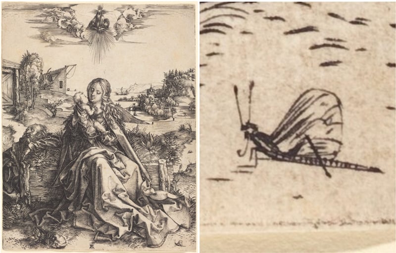
Such as this one from the famed German artist Albrecht Durer’s 1495 print “The Holy Family with the Mayfly,” where he included a mayfly in the lower right-hand corner to indicate, presumably, the ephemeral nature of life and, some scholars suggest, a “cosmic resonance between sacred and profane, celestial and terrestrial, macrocosm and microcosm."

Think about that for a second or two.
Albrecht Dürer, The Holy Family with the Mayfly,1495-/1496. / Source: National Gallery of Art
Albrecht Dürer, The Holy Family with the Mayfly,1495-/1496. 
In art and literature, mayflies commonly represent life’s fleeting quality. Consider this description in the Epic of Gilgamesh, circa 2000 BCE: Ever the river has risen and brought us the flood, the mayfly floating on the water. On the face of the sun its countenance gazes, then all of a sudden nothing is there.

It is important to remember, however, that in the mayfly’s pre-adult, nymph stages, it can live for more than a year underwater. Their adolescence ends in a brief but spectacular adulthood. Their relatively long composite lifespan, however, makes them an important bioindicator, subject as they are to water quality over time and not just in passing.

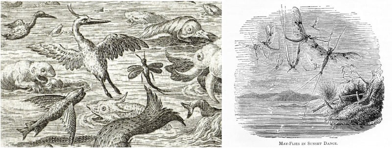
Mayflies are perhaps not as well known as American Woodcocks for their aerial displays of courtship, but in fact they don’t just mate in the air—they perform an elaborate dance that might be described as up-and-down movement, like a winged horse moving steadily if jerkily skyward. When the mayfly stops beating its wings, it gently falls, its abdomen almost vertical.

Check it out some summer evening. So sexy.

Left: Mayfly by Jan Sadeler after Maerten de Vos, detail from “The Fifth Day: The Creation of the Birds and Fishes,” 1587. Right: "May-Flies in Sunset Dance" by Philip Henry Gosse in a Victorian edition of Gilbert White's “Natural History of Selborne.”
Left: Mayfly by Jan Sadeler after Maerten de Vos, detail from “The Fifth Day: The Creation of the Birds and Fishes,” 1587. Right: "May-Flies in Sunset Dance" by Philip Henry Gosse in a Victorian edition of Gilbert White's “Natural History of Selborne.”

Mayflies often emerge in large numbers. That’s likely an evolutionary survival strategy, since any single mayfly is less likely to be eaten, statistically, when protected by the sheer numbers of the swarm, while at the same time, the hatch is an all-you-can-eat buffet for fish and birds. The hatch is often so large that it can be captured on radar by the NOAA weather station downriver in La Crosse, Wis., which has a web page for tracking mayflies.

Mayfly emergence, NOAA radar Imagery (La Crosse, WI),
June 1, 2023; 8:5 4-10:16 pm.
Next time you are shoveling dead mayflies off your patio or cleaning your windshield, take a moment to appreciate that they have ancestral traits probably present in the first flying insects, a storied history in art and literature, indicate a healthy ecosystem, and can cut a pretty move on the dance sky.

Thanks Steve! 

If you enjoyed this article, I highly recommend subscribing to the Frontenac State Park Association monthly newsletter edited by journalist and MN Master Naturalist volunteer Pamela Miller. It is full of lively nature articles, events at the park, poetry and photos that invite you to step out and learn about our natural world.

Tuesday, October 24, 2023

Hiking Groups - Try Them, You'll Like Them!

One of the pleasures I’ve found in hiking in the Driftless is discovering the MANY groups that exist around the area that coordinate or sponsor hikes. 

Driftless Drifters Hiking club pals on 
 Mathy Quarry's Snakeroot Trail
Image - Marge Loch-Wouters
While I have always done a lot of hiking, it was mostly with family and a few close friends. My first weekly group experience was with our local Driftless Drifters back at it’s beginning in 2021. Sponsored by the La Crescent-Hokah Community Ed Department, the group opened my eyes to the many trails that I had never tried locally. 

Each hike was not only a discovery of new trails but a feast of information shared by the hikers themselves. Flower and plant identification, bird calls noted and birds named and spotted, insects noted, fungi found and identified. That sharing enriched the trail for me and piqued my curiosity. It's a big reason why I went ahead and became certified as a MN Master Naturalist. I wanted to know even more.

Winona's TakeAHike club and the Driftless Drifter's
Amblers meet for a joint hike at
Great River Bluff State Park
Image - Greg Watson
I joined other groups like the Driftless area's Blufflands Hiking group and Jabberwalkers. I also began meeting people in other groups like the La Crosse-based Trek-N-Treaters and Winona-based TakeAHike group. I have hiked with some of those groups and discovered even more trails to try and friends to meet. Becoming active in conservation clubs like the Sierra Club or Friends of a local nature center, state park or outdoor area also means you will find like-minded trail hounds. Women Who Hike - MN chapter has also been a rich well of hiking adventures and hiking meet-up possibilities. 

Plus meeting so many other people with a shared love of nature, the outdoors, phenological curiosity, adventure and challenge is great fun. Those friendships on the trail developed, for me, into a great network of hiking friends who are up for hikes any time of the week and year - not just during weekly hikes. I hike a couple of times a week with friends I've met from the groups I've participated in.

On the Levis Mound trail with the 
Blufflands Hiking group
Image - Steve Dawson

If you are looking to spark up your hiking and find new people to share the trails with I highly  recommend checking into what is happening in your community. Or starting your own group of nature lovers on the trail! 

Hiking friends from the Trek-N-Treaters hiking club
in La Crosse County's Coulee Experimental Forest
Image - Marge Loch-Wouters

The world outside is waiting for you - and so are your new friends!


Tuesday, August 15, 2023

Upcoming Master Naturalist Training

One of the more life-changing events in my last few years was my certification as a MN Master Naturalist volunteer (MMNV) through the University of Minnesota Extension program. While I've always been an outdoors enthusiast, it gave me the tools to know more and be a more knowledgeable and committed volunteer in my community in preserving and enhancing natural areas.

Our April 2022 MMNV Cohort

There is a MN Master Naturalist volunteer training course coming up in September that focuses on two biomes along the Mississippi and Minnesota Rivers and the deciduous forests of the eastern regions of MN. I can't recommend it highly enough.

What's it all about?

For $295 (scholarships available), participants receive a textbook/materials and an intensive two-week training program consisting of 40 hours of classroom and field work plus completing a capstone project of their choice.  The instructors are the super-knowledgeable and super-enthusiastic Sara Holger and Jeremy Darst, park ranger/naturalists at Whitewater State Park (where the training takes place). Participants dive into the geology, history, ecology, hydrology, flora, fauna of the biomes and how to interpret nature for people. It's a fascinating and intense experience learning from instructors, field experts and doing volunteer work during that time. Plus you make alot of new friends in your cohort in the training that you can continue to learn from and connect with well after the training is done!

Weaver Dunes Field Trip

Once certified as a Master Naturalist volunteer, 40 hours of volunteer work annually are required to maintain one's certification. Those hours are easy to fulfill. You can do your volunteer work for parks, nature centers, your city via Park and Rec boards/commissions, interpretive hikes, trail maintenance; volunteering with Friends groups connected to large areas (conservancies, blufflands and prairie restoration); US and Fish and Wildlife sites and more. 10 of those hours can be be earned through training - workshops; webinars; presentations; guided interpretive hikes; field trips, etc. 

I mentioned life-changing at the beginning of the post. What did MMNV give me? First, a taste of all I didn't know. This past year has been full of opportunities to learn more on group hikes; from presentations and guided hikes and from solo hikes where I identify and re-identify all the flora, fauna and fungi I can find. On each hike I get a little better at spotting and identification. 

Checking out a sinkhole
on training field trip
It also gave me a chance to give back through volunteer work - planting trees and native wildflowers; leading interpretive hikes for kids and adults; assisting at parks and nature centers as a volunteer at events; serving on city boards/commissions preserving/enhancing natural resources and parks. Earning hours is a snap!

Everyone who is curious about the outdoors and everything in it is a naturalist whether they have taken the MMNV certification or not. For myself, the training fired me up even more and has placed me in learning situations with knowledgeable people that have advanced and deepened my understanding. 


There are still a few spots open in the upcoming course. I hope you consider this Sepember course or the spring course in April. You'll be glad you did.


Tuesday, July 25, 2023

What's in Your Pocket? Apps on the Trail

Or rather, what's in mine? 

In the grand tradition of EDC (every day carry), I want to share my favorite trail apps (at the moment).

While I'm a certified MN Master Naturalist volunteer, that doesn't mean I know ALL.THE.THINGS. It just means that I am willing to be a life-long learner in the natural world. Part of that learning goes on while I am on the trails during my various hiking adventures each week. As the seasons turn and various flora and fauna go through their life cycles and nesting cycles, my eyes and ears are attuned to what I'm seeing.

A typical scene when I am on my hikes
 id'ing stuff with my iphone
Image - Lloyd Lorenz
The challenge for me, as well as for many of us, is figuring out exactly what I am seeing and hearing. You would think I would know every natural thing I see (and have seen) by now. But I don't.  I'm STILL learning.

I always carry my trusty iphone, a favored piece of hiking EDC gear, to help me identify or verify what I see/hear. I never leave home without it!

Each season, I re-acquaint myself with what I encounter. The further into the season I go, the more I remember - although hiking companions hear me muttering identifications as I practice on every hike. And, for what I don't know, my apps and photos help me make the identification.

Here's what I use: 

iPhone 13 Pro Max photo app

This iphone version has a really excellent camera system and editing options that allow you to crop and straighten pictures. It also has a pretty good identification feature that gives you a first ID of flowers and fauna on the trails. I click on the bug or plant icon and I get a quick result that I can then add to the notes field.

This is a great "out-in-field" way to capture what flowers I am seeing while I am hiking. I also use it to record what I am seeing from trail-to-trail and day-to-day. 

Since I do weekly or bi-weekly phenology journal, it also helps me easily refer back to what I've been encountering.

I like to cross reference the ID with other apps I use once I'm back home to make sure the phone has the correct ID. Then I type the verified identification in the photo notes line. Pretty sweet!

Seek by iNaturalist


This app is a pretty huge delight on the trail. You just aim your camera at the plant, insect, fungi, amphibian, mammal, mollusk, reptile, bird, arachnid, fish (or other species). The app will often identify it on the spot. It then pops it into your observations which includes the date observed, its taxonomy, seasonal observations based on other users, range map of observations near year, similar plants and a short snippet from wikipedia (be sure to donate to them). If the identification isn't returned, you can forward the photo to the iNaturalist community for an ID. 

My only hesitations on this app is that the camera doesn't do great close-ups and it's hard to move photos from the iphone into this app. So it can be futzy on the trail. But for instant ID, it rocks.


PictureThis


I actually pay for this flower identification app for alot of its features. It is pretty darn good at flower identification accuracy. It is easily used to check IDs from my phone photos after the hike (or even on it, if I have cell service). I appreciate that feature because it two quick clicks from the photo to my confirmed id.

The identification includes a range of names for the flower including its scientific name. It has a FAQ area that often includes interesting tidbits that I can use when I am doing interpretive hike programs. They include characteristics of the plant, sometimes poems and symbolism, its taxonomy, range, where it is native, cultivated, considered invasive, garden use, and care guide.

It also saves my observations in "My Garden" so I can refer back when I am about to guide a hike. that I have scouted for flower and plant IDs. I can do my prep quickly and easily! All this info really helps me learn the plant better so the cost is worth it to me.

Merlin

Of course, you all yell! 

I have learned more bird song/call identification from this app than ever before. Created by the magical folks at Cornell Lab of Ornithology, this is most hikers' favorite app.

I really appreciate the sound ID, since birds often escape my eyeballs (except when I am with MN Master Naturalist friends and bird gurus Janet Malotky and Steve Dietz when all birds appear before my eye and binoculars). *

With Merlin, you can track not just what you are hearing, but locate the bird by following its sound to actually see them. Plus the app let's you hear recordings of birds to help you attune your hearing to the birds you are likely to hear at various times of the year.

AllTrails


Finally, you only have to hike with me for 4.5 minutes before you discover my sense of direction is absolutely nonsensical. If it's not a loop or an out-and-back, you may find me wandering 5 years later. It's why I heavily scout hikes I lead. I want to make sure no one follows me into the land of the lost!

For me the AllTrails app works swell. Like all crowd-sourced apps, you have to be on your toes - one person's hike doesn't always match another's or has weird names that don't really quite match the trails you are on. You can pre-download the map you want to use as the guide as long as you are aware you may want to hike that trail or trail system slightly differently.

On the good side though, you can just set the app to navigate and it will often display the trails you are on with names. While it sucks up battery while on the trail tracking your whereabouts, it has kept me on the straight and narrow every time I have used it.

I appreciate that it tracks mileage and elevation and that you can save your hike if you choose to. I use the app alot not just on the trail but for the blog to remind me of information. You can choose to review your hike after you are done or just look at the info and delete it.


What are YOUR go-to apps that help you stay on the trail, identify or make your hikes easier while you're hiking. Feel free to let me know in the comments or the next time you see me on the trails!  

*P.S. I really recommend going on one - or more - of their bird hikes at MN's Frontenac State Park. You will be gobsmacked and feel amazing at what you see thanks to their guiding.

Checking that ID
Image - Kris Lawson


Monday, June 26, 2023

Bird Banding Adventures (WI & MN)

In the past month, I've had the opportunity to observe and participate in two bird banding experiences. Both were great learning experiences and added to my Master Naturalist knowledge base.

Carefully removing the bird
from collection bag


In May, after a 3 year hiatus due to COVID and avian influenza, our La Crescent Natural Resources Advisory Group aka NRAG (I am a member) sponsored a 3 hour World Migratory Bird Day Bird Banding demonstration for our community at Vetsch Park, one of our local blufflands parks. We collaborated with U.S.Fish and Wildlife Service Biologists’ Banding Demonstration Team.

Making a precise identification


21 birds were caught and banded. We had 5 nets set up. The birds included American Redstarts (4), Magnolia Warbler, Song Sparrow, Gray Catbirds (6), Swainson's Thrush, Northern Cardinal (2), Common Yellowthroat, American Goldfinch (2) and Eastern Wood Peewee. 


Each bird was identified, weighed, aged and wings measured. In addition, they were checked for sex, fat stores and general health before they were banded and released. Observers often stayed for an hour watching the action or taking side trips led by NRAG members to see the rare showy orchid blooming on Vetsch's trails.


A very organized banding work space


It was the first time I had seen this work and I was very impressed with the process - especially the initial careful work in making an exact identification. Various sized bands were available to be used depending on the size of the bird. 

The data sheets were carefully maintained as the banders quickly worked to complete the banding and data so that the birds had the least amount of stress.


A banded bird ready for release

In the end the birds were quick to fly off. The data collected means migratory patterns can be tracked as well as information about the breeding and health of the birds, the success of their breeding, whether they arrive in their breeding grounds with sufficient food available and much more. 


In mid-June, I joined a colleague at a Natural Resource of Wisconsin guided field trip to observe a morning of banding at the Beaver Creek Reserve near Fall Creek WI. 

A mist net set up.

The field trip was described:

"The continent-wide Monitoring Avian Productivity and Survivorship (MAPS) bird banding program is a constant-effort mist netting project created by The Institute for Bird Populations in 1989 to provide  annual estimates of post-fledgling productivity, adult survivorship, and population size for resident breeding bird species.  Beaver Creek Reserve has run a MAPS station at the Henke Farm continuously since 2003. This is a great opportunity for visitors to observe data collection for a long-term project and see birds in the hand. Over the years the Beaver Creek Reserve MAPS program have captured 1,654 birds of 59 species. Species list include gray catbird, golden-winged warbler, indigo bunting, veery, song sparrow ... Join us as we cover the diverse habitats at the Henke farm and see some of Wisconsin's magnificent birds up close."


One of the many amazing banding volunteers


We got to observe the crack team of volunteers collecting, identifying and gathering data from each bird that was netted that morning. Participants walked the net lines and were treated to lots of information on migratory birds from the VERY knowledgeable staff and crack volunteer team. There were twelve nets scattered in hardwoods, prairies, wetlands and pine stands. Every 30 minutes, three groups of volunteers, staff and field trip participants split the work of checking nets to recover birds.


Safe from mosquitos, the banders had
2 stations inside to do their work


The banding team worked in a great "bird cage" structure built by an Eagle Scout. It was completely screened in with a transparent roof giving plenty of light to the data collection and banding work. The screened windows allowed us to observe the banding as banders walked us through notable characteristics of breeding songbirds. We had a fascinating birds-eye view of the banders at their precise work. 


Karen Wittig transferring a warbler to me for release.
Image - Kris Lawson
Some participants also had a chance to gently release the banded birds. I felt lucky to have that privilege.


One of the many highlights of the trip was meeting and talking to Pat Henkes. She and her husband donated the 400 acre Henke farm to the reserve - and Pat made us gingersnaps! The restored prairie is alive with flowers and pollinators and the woods were full of birds including chestnut-sided warblers, common yellow throats, veery indigo buntings and more.


Learning opportunities like this abound. They stretch our understanding and help focus on on ways we can do citizen science work and help advance everyone's understanding of our natural world.


Imaged, unless noted - Marge Loch-Wouters

Monday, June 19, 2023

Make a Hiking Visit to Frontenac State Park (MN)

I wanted to do a special focus on MN's Frontenac State Park, north of Winona and a few miles south of Red Wing. I have only hiked a few trails there so I am by no means an expert but it is a favorite stop when we are traveling the Mississippi River Rd on our way up to the Twin Cities or just because. 

Bruce Ause showing bluebird chicks
 on a Saturday Naturalist hike

The park features a variety of trails and terrains (prairie, hardwood forests, blufflands, floodplain forests) as well as stunning views of the Mississippi River and Lake Pepin. There are birds a plenty and wildlife. 

I have attended two of their awesome programs and can't say enough about how informative and fun they are. Throughout the summer on Saturdays from 10-11am, naturalist Bruce Ause takes you on a nature walk through the ever-changing woods and prairie. Monthly Bird Walks on Saturday mornings at 8am hosted by MN Master Naturalists Janet Malotky and Steve Dietz help you really SEE the birds!

And, for me, best of all, a wonderful free online newsletter that helps me discover all the programs and information I need to make the most of my time there. Written and edited by Pamela Miller, a sister MN Master Naturalist and member of their very active Frontenac State Park Association, each monthly issue highlights the best of the park and it's staff, volunteers, programs and ruminations on what can be found inside the park. Pamela has a great dry sense of humor and every issue is a gem. Subscribe!

I want to share an article, "Trails to Try" from the Frontenac State Park Association's most recent issue that contains some great trail recommendations depending on your situation. :

"One of the many things that makes Frontenac State Park special is the diversity of terrains it enfolds. On a single long hike, you might walk along bluffs, on prairie, and through hardwood and floodplain forests. How to choose a trail? Print out a trail map ahead of time or grab one at one of several handout sites. And consider this cheatsheet:

You don’t have much time, have small kids in strollers, are pushing or in a wheelchair, or of limited mobility: Travel the paved path that runs along the top of the bluff near the main overlook and all the way to the campground. It’ll lead you, gently, past breathtaking views and through mature maple-dominated woodlands.

You like a challenge, your knees are just fine, and your Fitbit is itching for a whole buncha stairs, because that’s how you roll: The Upper and Lower Bluffside Trails are a beautiful challenge. They feature rocky trails with many limestone or wooden stair steps leading to a view of Lake Pepin. Not recommended for little kids, unless you can stuff them into your backpack.

In the Forest at Frontenac
Image - Marge Loch-Wouters

You prefer gentler hills, and love mixed woodland and prairie:
 Follow the Hiking Club Trail, marked in yellow on the park map. Everything about it is just lovely, especially the Eagle Point overlook. We recommend, however, that you use a park map to keep track of whether you’ve passed points F, G, H, I, J, K or L on the trail, because otherwise you might find yourself walking round and round and round in beautiful, familiar circles, sort of like the first time you drove in a roundabout. (Don’t ask us how we know that.)

Bonus loop: Several of the trails mentioned above link to the Pine Loop Trail, an unexpected, quiet, level loop of towering white pines planted long ago by a farmer. Rest on one of the loop’s rustic wooden benches and watch for owls sailing through the pines.

You love bluebirds, meadowlarks and prairie grasses swaying in the wind: Follow the gently rising and falling Prairie Loop trail, which starts on the south side of County Road 2 and curls over to Pleasant Valley Lakelet, which features a nifty wildlife viewing blind that kids, especially, will love. A lot of this trail is under the blazing sun, so wear sunscreen and a good hat, eh.

You want to see a floodplain forest and sandy beach, neon-colored little frogs, and the sometimes rare birds that live in both areas: The Sand Point trail begins away from the main park area. Bike or drive to the small parking area off Hwy. 61 and County Road 2 and follow the signs. It’s especially important to remember your mosquito repellent for this one (don’t ask us how we know that).

Want to see the park’s newest area?: Check your park trail map for the as-yet-unnamed trail southwest of Hill Avenue. It’s a steep loop up to a gorgeous view to the southwest and southeast of what’s historically been known as Waconia Cliffs, acquired by the park in 2020.

You prefer a trail less traveled: Frontenac State Park is a sprawling place, and the park map doesn’t show it all. If you’d like to explore some less-traveled paths, go to the park office and ask for directions to the two trailheads on the north side of Hill Avenue (or you can email pamelamarianmiller@gmail.com for maps and info). Both are moderately challenging hillside climbs that lead to high prairie paths that go northeast to the bluffs overlooking Lake Pepin. One is called the Santelman Firebreak trail, the other the Rattlesnake Bluff trail. Yes, there are some endangered timber rattlesnakes up there. No, you are not likely to be lucky enough to see one."

June 23, 2023 issue. Pamela Miller

Image - Pamela Miller

So head up or over to this great hiking park - and sign up for the free online newsletter too. You'll be glad you did!

Images, unless noted - Marge Loch-Wouters

Friday, June 2, 2023

Family-Friendly Driftless Trails - Further Afield Trails

In this series of posts, I am sharing some easy trails that are perfect for families who want to get out in the woods. I developed these lists as part of my MN Master Naturalist capstone project in April 2022. I love connecting people to lots of trail options to explore!

The hikes below are the last in the series. The links at the bottom of this post go to lists of additional hikes in nearby areas.  I continue to add new destinations, so if you know of any hikes in this area, let me know in the comments!

Happy summer hiking!

Image - Gregory Watson


FURTHER AFIELD
Genoa National Fish Hatchery and Great River Road Interpretive Center, S5631 State Highway 35, Genoa, WI
The Great River Road Interpretive Center and hatchery is a must stop. Free admission Find out about the work of the hatchery and see live fish in the aquariums. There is also self-guided walking tour of the hatchery, a nature and wetlands boardwalk trail behind the interpretive center. The Visitor Center is open 9-3 weekdays, closed weekends so plan accordingly. The staff is always super helpful. Restrooms at Visitor Center. Trails are easy.

Driftless Area Education and Visitor Center, 1944 Columbus Rd, Lansing Iowa
Another outstandingfree resource that focuses on cultural, historical and natural history of the Driftless area and Mississippi River. While there are no trails, head down the road and up the bluff in Lansing to…

…Mt Hosmer Park, 271 Main St, Lansing, IA
Drive up to the top and walk along the safety fence for spectacular views of the Mississippi River and WI bluffs. Restrooms, shelter and picnic areas available. Walk along the quiet park road to see huge pines and beautiful views. https://www.mylansingiowa.com/mt-hosmer-lookout-and-park/

Sugar Creek Bluff State Natural Area, N. Buck Creek Road Ferryville - Head south on Hwy 35 to Ferryville until about 1 mile south of town and turn left on N. Buck Road. Drive up about a mile until you see a Mississippi Valley Conservancy kiosk on the left.
You’re almost on the top of this beautiful mixed savannah/oak prairie and mixed hardwood trail (1.5 miles out and back) that leads out to a great high view of the Mississippi River and MN/IA bluffs. There are slight elevation gains on this grass and dirt trail.

Fish Farm Mounds State Preserve, 3 miles south of New Albin IA on Hwy 26
Climb 50 stone steps to this hidden gem with a series of 30 conical burial mounds of indigenous peoples built between 100 BC-650 AD. There are also some short trails behind the mounds. You can read about the fascinating history in this 2020 Big River Magazine article.

For more destinations in this series, check out these blog posts:

Family-Friendly Driftless Trails - La Crescent and Nearby MN Trails

Family-Friendly Driftless Trails - La Crosse/Town of Shelby (WI) Trails

Family-Friendly Driftless Trails - Onalaska/Holmen (WI) Trails

Images, unless noted - Marge Loch-Wouters

Looking for more area hikes? Please stop by the web version of the blog and under the "Labels" tab on the right hand side of the blog, click on "find-a-hike". There are over 75 hike descriptions and lists of hikes to try!


Thursday, June 1, 2023

Family-Friendly Driftless Trails - Onalaska/Holmen (WI) Trails

In this series of posts, I am sharing some easy trails that are perfect for families who want to get out in the woods. I developed these lists as part of my MN Master Naturalist capstone project in April 2022. I love connecting people to lots of trail options to explore!

The hikes below are the third in the series. The links at the bottom of this post go to lists of additional hikes in nearby areas.  I continue to add new destinations, so if you know of any hikes in this area, let me know in the comments!

Happy summer hiking!

Image-Gregory Watson


ONALASKA/HOLMEN

McGilvray 7 Bridges, N8327 Amsterdam Prairie Road, Holmen
Located in the Van Loon Wildlife area, the six historic bridges on the trail and the wetlands are key features on this trail that ends at the Black River. Plenty of wildflowers and wildlife on this flat former road. Not recommended during high water or in the height of mosquito season. But winter and fall are great seasons; this is also a hunting area so wear blaze colors and stay on trail. Approximately 3.5 mils out and back.

Halfway Creek Park, 300 W. Roberts St, Holmen
Moderate, mostly flat or gentle elevation gains along Halfway Creek trail featuring bridges, wildflowers and wildlife along the crushed rock trail that follows a beautiful creek. Restrooms and picnic area available at the park. Approximately 3 miles one way so go as far as you like before turning back.

National Wildlife and Fish Refuge Visitor Center, Brice Prairie, N5727 Cty Rd Z, Onalaska
Easy paved/gravel trails wind through sand prairie and to a Lake Onalaska outlook deck. Abundant flowers, wildlife and an excellent Visitor Center. Restrooms available. Approximately 2.5 miles of trail loops.

Holland Sand Prairie, W7781 County Road MH, Holmen
Fairly flat with some rolling hills on grass/dirt trails for views of a beautiful sand prairie with abundant wildlife and wildflowers. There is a 1.3 mile boundary trail and a shorter .5 mile trail through the center of the Mississippi Valley Conservancy property.


Lytle’s Landing, W8582 Lytle Rd, Holmen WI
Part of the Great River Bike Trail, this flat section goes over 4 old railroad bridges across the Black River floodplain forest wetlands. Abundant wildlife and many hikers and bikers on this lovely section. Especially noted for its migratory birds and waterfowl.

La Crosse River Conservancy, 3060 S. Kinney Coulee Rd, Onalaska  Park near Stoney Creek Inn or the Gundersen ramp. Start at the trailhead by the Mississippi Valley Conservancy kiosk at the west end of Stoney Creek Inn.
Wetland prairies, swamps abound in this pretty little river valley that was restored from former farmland. The property is one of the Nature Reserves of the Mississippi Conservancy.

La Crosse River State Trail, Medary Trailhead (Take Hwy 16 north towards the mall and turn right on Cty B, go .3 miles and turn left into the parking lot)
On this flat gravel biking/hiking trail, once a railroad bed, you’ll see prairie remnants, hardwood areas and wetlands. Abundant wildlife can be found along this bike/hiking trail. Head out-and-back as you'd like

Great River State Trail,- 101 Irvin St, Onalaska
This trailheadbrings you down to a flat gravel hiking/biking trail that follows the Mississippi and Black river, a spillway, Lake Onalaska trains and wildlife. Head out-and-back as far down this trail as you’d like!

For more destinations in this series, check out these blog posts:

Family-Friendly Driftless Trails - La Crescent and Nearby MN Trails

Family-Friendly Driftless Trails - La Crosse/Town of Shelby (WI) Trails

Family-Friendly Driftless Trails - Further Afield Trails


Images, unless noted - Marge Loch-Wouters


Looking for more area hikes? Please stop by the web version of the blog and under the "Labels" tab on the right hand side of the blog, click on "find-a-hike". There are over 75 hike descriptions and lists of hikes to try!