 |
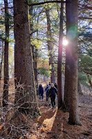
Huge pines on the trail
Image - Steve Dawson |
Thanks to a hike guided by Steve Dawson of the
Blufflands Hiking group in mid-January, I was introduced to this great winter hiking trail. In the past month, I've returned with friends and family a number of times.
Located in Fort McCoy near Sparta WI, the Pine View is a popular and busy campground in the warm months of the year.
But during the quiet times of the cold winter, the trails are nearly empty. And what is the draw in the winter?
 |
| La Crosse River near it's source |
The La Crosse River. It flows just behind the campsites between the trails on the loop and creates a stunning hike in the bleakest times of winter. The source of the river is nearby and the waters - just the size of a healthy stream here - meander, creating a beautiful setting in a forest filled with giant pines and hardwoods.
 |
| Trout Falls |
The trout-filled river with its icy edges flows swiftly and features some rills and Trout Falls, a gorgeous small waterfall as well as crystal clear waters. The main trail is a 1.5 mile mostly flat loop trail perfect as a gentle amble hike or a regular hike. It is a delight in snowless cold months to have the river alongside as you hike the trail. It brightens those usual brown-and-buff snowless hiking days. And the towering pines add to the ambiance and glory of the trail.
 |
| One of many bridges |
The first time I hiked this trail, I thought I HAVE to snowshoe this - it would be perfect. And indeed it is! When it snows, the trails are a snowshoer's dream. The river's icy edges contrast with the flowing water as you cross multiple bridges on the main loop trail. There are numerous spots to enjoy the river view along the way. The short length and flat terrain make it perfect for beginner snowshoers as well as vets.
There is enough dense brush and invasives along the river trail that it's hard to do off-trail snowshoeing. Further from the river, there are a few open areas to tramp that have a clearer understory. While I usually love a good off-trail tramp while snowshoeing, the trails here are pretty enough to satisfy me.
At the halfway point on the trail, you come to Trout Falls, which is clearly a
very popular place in the summer. Beyond the falls, the river quietly pools and flows around some stunning rock formations. You have to fight through brush to see this but it is worth the effort.
There are additional trails that follow a disc golf course on the southwest side of the river that can add another mile or so to a snowshoe adventures as well. They can be slightly confusing beyond the main trails but that's why snow is nice. You can always easily follow your trail back. There are also little narrow, rough, alternative trails near the river that you can wander on.
Other than a rustic map at the trailhead near the main entrance, there aren't detailed maps of the hike. There is parking near Trout Falls that one can also use to access the trails as well. To the left is my AllTrails map from February 21.
 |
| Trout falls |
This river trail loop will remain a go-to winter destination for me. It's quiet forest beauty and close river views are refreshing during long snow-drought days of recent winters. And during snowshoe treks, the snow blanketed forest and ice formations make a beautiful and easily snowshoed scene.
THE HIKEA 1.5 mile loop trail on both sides of the narrow La Crosse River and under a canopy of massive mature pines and hardwoods make this mostly flat trail a jewel for easy winter hiking/snowshoeing. Multiple short bridges along the route add to the fun. Trout Falls at the halfway point is a high point. There are info kiosks along the trail highlighting the flora, fauna and terrain of the area.
 |
| La Crosse River |
The Location
Don't trust your GPS on this one or you'll end up at Fort McCoy's front gates. These directions will get you to the trailhead: From Sparta, take Hwy 21 east until you see the large Pine View Campground sign. Turn there. Follow the road for 3/4 of a mile and turn right by the sign that says "White Tail Ridge". Follow that road until the yield sign at the end (ignore the sign you’ll see on this road that indicates a right hand turn to the campground). Turn left and follow the road .6 miles and take a right at the campground entrance. Immediately take a right again onto an unplowed campground road and follow it around until you see playground equipment with a basketball hoop on your right. Park by the net. Head west beyond the playground equipment and you will spot the trailhead!
 |
| At the foot of a BIG pine |
Images, unless noted - Marge Loch-Wouters
Looking for more area hikes? Please stop by the web version of the blog and under the "Labels" tab on the right hand side of the blog, click on "find-a-hike". There are over 75 hike descriptions and lists of hikes to try!


No comments:
Post a Comment