Showing posts with label glaciers. Show all posts

Friday, October 20, 2023

Hiking the Drifted - North Shore/BWCAW

Over the past four weeks, I twice found myself up on Minnesota's North Shore for hiking and paddling adventures lasting a week each. I always enjoy hiking areas with different geological characteristics. And much like hiking in the southwestern US, the North Shore has a ton of great geology and challenging hikes thanks to glaciers and the pyrotechnics of the land's formation.

The first week was primarily a paddling vacation with my canoeing buddies into the Boundary Waters Canoe Area Wilderness (BWCAW) out of Ely, MN. I was testing out my shoulder after a year-long rehab to see if 6 hour paddles and portaging our Wenonah canoe were still in my toolbox. Mission accomplished - they are. 

Can still portage and paddle!

The second week, my honey and I headquartered near Grand Marais for hikes and leaf-peeping in the Superior National Forest along the Gunflint Trail, in the Sawtooth Mountains and along Hwy 61.

I had plenty of great hiking adventures throughout those two weeks. These trails feature sharp, steep inclines and winding, twisting and often-tree-root-ridden trails. The evidence of the imperviousness of Canadian Shield rock screams at you as you tackle these trails. Finding "easy" or flat trails is a completely different venture than in the Driftless area. I find this hiking good for the soul and soles.

My hikes included:

Eighteen Lake

Eighteen Lake,
Superior National Forest, Tofte District

Located near Isabella, MN off Hwy 1

This 2.9 mile hikes closely follows the shore of a small lake located in the Superior National Forest. Wetlands, hardwood forests, pines, small creeks and a few steep climbs to outlooks are all rolled up in this hike. The trail is clear although a bit overgrown in low-lying areas. The two or three steep climbs are primarily in the section to the right of the small (4 sites) rustic campground. The views are so worth it! I would rate this as moderate due to overgrowth on many parts of the trail and extremely steep hills to the outlook.

Dry Lake Trail
Dry Lake Trail,  Superior National Forest, Kawishiwi District

Located near Ely MN off Hwy 116

This is a loop trail but we decided to do an out-and-back after talking to hikers who said the northwest section of the loop was very difficult due to so many large rocks and exposed roots. We hiked 2.5 miles from the Basswood Lake trailhead and back. The trail is rolling and twisty with a number of outlooks along the way that give dramatic views of Basswood Lake. There is a small waterfall that was very dry this time of year but it was definitely a fun if challenging hike with elevation gains of 275 feet. I would rate this as moderate.


View from Wolf Rock
Wolf Rock, Superior Hiking Trail, Castle Danger to Gooseberry Segment

Located near Castle Danger, on Hwy 106, off Hwy 61

While this trail segment of the SHT heads approximately 9 miles to Gooseberry Falls, we were most interested in the very first half-mile section that leads to Wolf Rock. For a quick but steep hike, the reward is expansive views of Superior National Forest, Crow Creek Valley, Lake Superior and the Sawtooth Mountains. Not bad for a mile out-and-back!  Like almost all SHT segments, the trail up and down is seriously serious - but once up on the ridge the hike is easy - and those views!

My new fascination -
rockcap ferns at Topper Lake portage
Topper Lake Portage, BWCAW, Superior National Forest, Gunflint District

Off the Gunflint Trail, Forest Rd 317 (Mayhew Lk Rd)

A small sweet trail (especially sweet without a canoe to portage!) through wetlands and mixed forest features a huge boulder strewn area with ferns, lichen and moss growing everywhere. Less than a mile but a great stretch when driving up the trail to the Chik-Wauk Museum at the end or the Trail Center restaurant in the middle of the Gunflint Trail for the best malts and shakes around.


Divide Lake

Divide Lake Trail
, Superior National Forest, Tofte District

Near Isabella MN, off 600 Rd.

Tucked deeply into the forest, this beautiful canoe lake straddles the Laurentian Divide. On one side of the Divide, the waters drain to Lake Superior; on the other, the waters drain to Hudson Bay (Divide Lake's waters drain to Superior). This 2.7 mile hike was probably the flattest of all these hikes. It meandered around the larger lake on the east side of the road. The trailhead is at the 3-site rustic campground. There are a number of benches along the trail that winds gently up and down through hardwood and pine forests. There is a backpack site to peek at on a spur off the trail. 


Temperance River Loop
Image - Lloyd Lorenz

Temperance River Loop
, Temperance State Park

Near Silver Bay on Hwy 61

A popular hike is best done on a cool early morning with rain threatening. It guarantees few to no people on the whole trail! This 2.5 mile hike starts dramatically following the falls and gorges of the Temperance River as you climb and clamber up rocks and rock stairs to a multitude of stone-fenced lookouts along the first 1/4 mile of the trail. The Gitchi-Gami bike path crosses the trail at the bridge. From there you continue to ascend as the river slows. Continuing on this 2.7 mile loop, you once more climb steeply to another set of falls (more difficult to see) before turning and heading through gorgeous hardwood forest to rejoin the gorge trail for the final quarter mile back to the trailhead. The iconic stone fences and amazing views and the seldom-hiked back part of the loop keeps this hike as one our favorite of the massively used state park trails on the North Shore.

All images, unless noted - Marge Loch-Wouters


Monday, July 31, 2023

Where IS the Driftless?!?!

The "driftless" is a rare unglaciated area primarily located in west central and southwestern Wisconsin along the east side of the Mississippi River and just kissing northwestern Illinois. While both southeastern Minnesota and northeastern Iowa seem to share the same characteristics of the Driftless, they are actually not part of the unglaciated area and are outside the actual Driftless area.

From Wisconsin Geological and Natural History Survey. The Driftless Area. Educational Series 057.
Carson, E. C., Curry, B.B., Kerr, P.J. Lusardi, B.A.  University of WI Madison, 2023.

That can sometimes be hard for people to wrap their heads around. The area is a special gem of steep bluffs towering over the Mississippi River and a winding network of long valleys, bluffs and steep hills continuing outward from the river that create a magnificent landscape. It is a challenging environment in which to build, farm and recreate in. We all want to claim it as our own and have a fierce love of this landscape.

Alot of areas in southeastern Minnesota and northeastern Iowa across the Mississippi River sure look like the Driftless area to the west in Wisconsin and Illinois. There is a tendency - which even I have shared - to claim these nearby areas as part of the Driftless. But they actually experienced glaciation during the Pre-Illinoian Glaciation era (500K-2,600K ago). These areas don't display the lack of glacial sediment or "drift," as it was called in the mid-19th century, that the Driftless does.

A just-published pamphlet "that describes and outlines the boundary of the unglaciated Driftless area based on modern geologic evidence" breaks down the differences in easily understood language. Titled The Driftless Area: The Extent of unglaciated and simitar terrains in Wisconsin, Illinois, Iowa and Minnesota, and authored by members of each states' geological survey team, this brief pamphlet (2 pages of text and 2 pages of citations!) is a perfect short explanation of what is the Driftless area - and what isn't.

Because the Driftless area in Wisconsin and Illinois never experienced glaciers, it is truly "the Driftless."  The rugged landscape of bluffs, steep hillsides and coulees displays no evidence of glaciation. Rather the landscape was formed by rivers cutting down through the sediment and forming deep valleys. 

In surrounding areas in portions of southeastern Minnesota and northeastern Iowa, there is clear evidence that the Pre-Illionoian glaciation left glacial landforms and sediment.  However, because they are Mississippi River-adjacent, they were also steeply cut into by rivers and so they are topographically similar to the Driftless.

The four-state geological survey team suggest that it would be more accurate to say these areas display "Driftless-style topography." They are not truly Driftless.

From Wisconsin Geological and Natural History Survey. The Driftless Area. Educational Series 057.
Carson, E. C., Curry, B.B., Kerr, P.J. Lusardi, B.A.  University of WI Madison, 2023.

I'm perfectly good with being Driftless-adjacent in Minnesota. I'll be keeping the blog title as is but I'll be going back and adding a "Driftless area" tag to all blog posts of hikes that are truly in the Driftless. I also edited the blog's header slightly to reflect more accurately the distinction.

The more we know, the more we grow!  I love how scientific knowledge keeps evolving as research and knowledge is continually added to. It helps us to better know the world around us even as it refines - and sometimes - shakes up our understanding. 

Monday, June 12, 2023

Hiking the Drifted - IAT Segments Near Aniwa (WI)

During the week following Memorial Day, I spent some quality time with hiking buddies from WI, exploring three segments of the Ice Age Trail in northern WI's Marathon and Langlade counties near Aniwa and Summit Lake. The Ice Age Trail (IAT) is a 1200 trail through WI's glaciated area that hugs the edges of the WI areas where the glaciers stopped. We left cars at both ends of the trails so all our hikes were one way.

Head nets and a rustic river crossing


As I mentioned in a previous post, hiking in the "drifted" area of WI and MN is quite different than the Driftless area. Our unglaciated high bluffs scream "Climb high on me!" The Ice Age Trail on the other hand is land that was ground down by the glacier and runs along its terminal moraine. This makes for rocky trails (or boulder-y as the case may be) and roller-coaster-y hiking. 

With their boggy sections and the ticks and mosquitoes out in force, head nets and/or a lot of DEET were a must. Actually, they kind of saved us - we were able to hike at a leisurely pace with no bloodletting.


A rock river crossing with perfectly placed
rocks that were "rock steady"


Plover River Segment
(3 mile portion - Sportsma's Trailhead to Hwy 52 Trailhead)

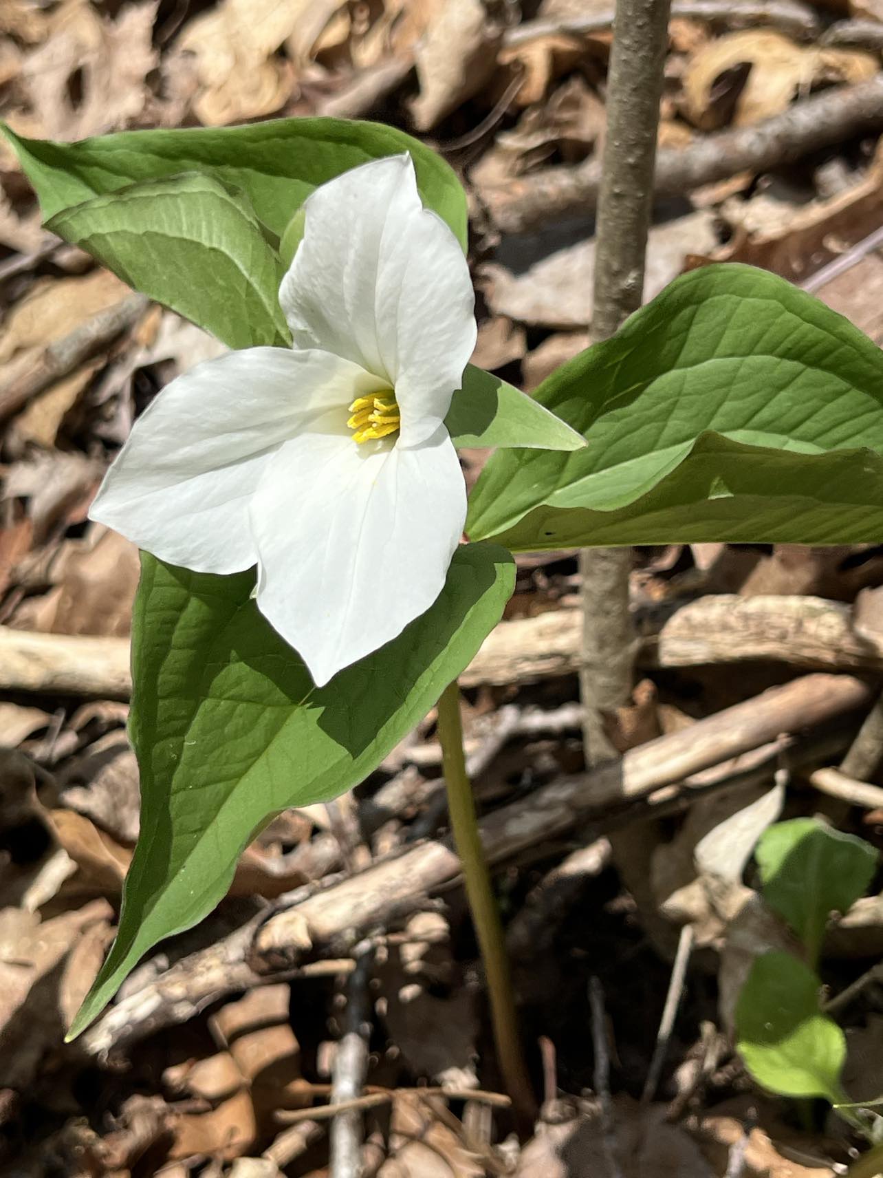
We started at at the north end of the segment and worked our way south along the Plover River. We had some welcome boardwalks to get over the very wet boggy area and some river crossing as we hiked  The wildflowers were profuse - trillium, Canada mayflower, starflower, blue-bead lily and wild sarsaparilla were the thematic flowers for all three hikes. 

From its's boggy portions, the trail climbed up and down and included a great rock river crossing. The rocks were well-placed for hopping and steady as...a rock - no tipping. We were all impressed with the work of the IAT volunteers who maintain this trail. Their care and detailed building work made the trail a joy to hike!

The hike wound through fields of trillium in the hardwood forest - and fields of huge boulders left by the glaciers. The views of the river peeked in and out all along the trail. After crossing one final bridge at woods' end, we hiked through open grasslands to trailend. It is a delightful trail and I would highly recommend it for all hikers.

Nearing the end of the Plover River trail.
Image - Susan Knorr

Dells of the Eau Claire Segment (2.6 mile portion - Dells of the Eau Claire County Park to Hwy Z Trailhead)

Eau Claire River along the trail

This segment was far and away the most picturesque of the three IAT hikes we did in the area.  The Dells are truly magical. 

Mylonite bedrock boulders

We started at the south end of the segment in open fields and prairies and headed north. At the start, the young, sun-lit forest and grassy areas were again full of wild flowers. Soon we hit the Eau Claire River and followed it's swiftly flowing waters for the rest of the hike though huge boulder fields and mature forests.  

Near Sandberg Island at the southern boundary of the county park we passed the 45th parallel, halfway between the equator and the north pole. Stairs led down to the river and at low river levels, it looked like hikers could rock hop over to the island.

Hanging out in the dells
Image - Michele Besant

The reminder of the hike closely hugged the river and brought us to the main area of the dells, huge mylonite rock formations rising along the river banks. There were multiple places to head down to the banks and admire the rocks. Near hike's end, we crossed a massive old CCC constructed stone bridge with great views of the river. The hike ended in the county park. The trail is very easy, fairly short and connected to the county park trail system so it can be busy. We lucked out and had the trail to ourselves!


Highland Lakes Eastern Segment (2.8 mile portion, Deep Wood Rest Stop to Hwy B Trailhead)

This was our least favorite trail of the week, not least because we played Pied Piper to swarms of mosquitoes along the whole length of the hike. While no blood was spilled, it was an unceasing and annoying accompaniment to a ho-hum trail.

Open boggy area near Lake Susan


The first part of the hike went through a lovely wooded area along eskers and kettles and up and along a ridge to excellent views of Lake Susan. From the woods, the trail came out onto a gravel road that descended into an open boggy area. 

From there we followed the wide, graveled entrance road of Camp Susan through hardwoods, large swaths of firs and hummocky scenery. It was bird heaven on this hike. We heard and saw a fine variety of songbirds and waterfowl. 

While the scenery was nice, the wide road took away some of what we love about trail-hiking - narrow trails that bring you right into the topography and flora and busy life of the woods. Except for the slight elevation in the trail to the ridge, this is a hike that is quite easy for all levels of hikers. 


Images, unless noted - Marge Loch-Wouters

Sunday, June 4, 2023

I Spy on the Trails - Week of May 28, 2023

The temps this past week reached into the high 80s and low 90's. Combined with the lack of rain over the past week and the haze from the continuing Canadian wildfires, hiking has been somewhat uncomfortable.  Water levels are going down although the Mississippi River continues at a slightly higher level and flow rate than usual at this time of year. 

All my week's hikes were in the north central region of WI and most were on Ice Age Trail segments - hardwoood forests, eskers and kettles and plenty of wet boggy areas. And rocks, many many rocks since these trails are along the terminal moraine of the glaciers.. Both mosquitoes and ticks were fierce. The full strawberry moon was a highlight as it waxed through the week. I also got to stand on the 45th parallel, north latitude (halfway between the equator and the north pole), on a hike which was fun!

Wildflowers

Wild sarsaparilla and trillium


  • Trillium
  • Wild Sarsaparilla
  • Bunchberry
  • Dryad's saddle
  • Swamp saxifrage
  • Wild geranium
  • Red baneberry
  • Wild blue phlox
  • Two-leaf miterwort
  • Blue cohosh
  • Meadow rue
  • Downy yellow violet
  • Eastern waterleaf
  • Blue-bead lily
  • Canada mayflower
  • Meadow buttercup
  • Water avens
  • Starflower
  • False Solomon's seal
  • Horse tails
  • Ferns (Ostrich, maidenhair, sensitive, interrupted)
  • Pussytoes

Wildlife (Seen, Heard)
Well camouflaged toad


  • Common loon
  • Barred owl
  • American Redstart
  • Red-eyed vireo
  • Ovenbird
  • American toad
  • Black-throated green warbler
  • Indigo bunting
  • Common yellowthroat
  • Veery
  • Wood thrush
  • Canada warbler
  • Catbird
  • Least flycatcher
  • Hermit thrush
  • Great crested flycatcher
  • Rose breasted grosbeak
  • Eastern phoebe
  • Eastern wood pewee
  • Mourning warbler
What are YOU noticing on your hikes?

This week's hike's: Erbach Park Trails, Athens (WI), IAT* Dells of the Eau Claire Segment Trail, Aniwa (WI), IAT* Plover River Trail Segment, Aniwa (WI), IAT* Highland Lakes Eastern Segment Trail, Langlade Co. (WI)

*IAT - Ice Age Trail

View of the Eau Claire River

Images, unless noted - Marge Loch-Wouters

The "I Spy on the Trails" column is a phenology (the study of seasonal changes in plants and animals) journal to chronicle year-round the weather, plant life and wildlife I observe while hiking. It is very useful in helping me compare observations from year-to-year. The column is published monthly from September through April and then twice-a-month from May through August when warm weather brings the natural world back to vibrant life.   

Friday, May 12, 2023

Hiking the Drifted - IAT Chippewa River Segment (WI)

The WI Natural Resources Foundation annually sponsors over 260 field trips from April -November. The widely varying trips might be hikes, climbs, paddles, hands-on work with resources or rides to see a natural phenomenon. These low cost trips have a strong learning component.

Image - Lavon Court
Recently, a friend and I went on one of their three-hour, 4 mile hikes on an Ice Age Trail (IAT) in north-central WI on the Chippewa River segment near Cornell. The IAT is a 1200 trail through WI's glaciated area that hugs the edges of the area where the glaciers stopped. The trails wind and head up and down over moraines and around kettles. 

The glaciated terrain is quite different from the Driftless where we have more massive bluff trails and flat river trails. The moraines and kettles that the glaciers carved create rolling landscapes with plenty of rocks that "float" to the surface. Trails meander around these hilly features and the bogs and marshy wetlands are part of the kettles throughout the glaciated area.

Image - Lavon Court
While our hike focus was on wildflowers, we also learned about how glaciation impacted the trails and area we were hiking in. I was particularly interested to see the flora 100 miles north of us and compare it to the wildflowers we are currently seeing in the Driftless. The trees on the trail were *just* beginning to bud (here the leaves have busted out in earnest and we are in shade tree heaven).


My expectation on this hike: I would see many of the ephemerals that had been abundantly present in our area 1.5 -2 weeks ago. But I got a surprise!

We saw many of the same ephemerals blooming there as we have blooming here - despite the distance! Along the trail, I saw early spring beauties along with a huge number of fully bloomed trilliums. I don't always find those two flowers blooming at the same time. We also saw two-leaf miterwort, marsh marigolds, little leaf butter cup, bellwort, white and yellow blooming trout lily, woodland horsetail, white rattlesnake root, wintercress, meadow rue, wood anemone - and a wood frog!


The hike itself was very interesting - especially in pre-mosquito times. With the lowlands and bogs as well as springs and rills, it is a wet environment - especially in the spring season. The trails are well maintained by the local Ice Age Trail Alliance folks. It is a fairly easy to hike and has great views of river, wetlands and forest.

THE HIKE

A 4 mile, out-and-back hike that starts along the steep north shore of the Chippewa River (the terminal moraine for the glacier) across from Burnet Island State Park. After a short segment, cross the highway and head into the Krank Nature Preserve (Chippewa County Land Conservancy made possible through the Knowles-Nelson Stewardship program) where the trail has plenty of ups and downs and twists and turns following the moraines and skirting many kettles and lowland bogs through hardwood forests. Trails can be muddy.


Location:  23778 County Highway CC, Cornell, WI 54732

From Cornell, WI: take Hwy 64 (Bridge Street) west across the Blue Bridge. Turn right on Hwy CC.  Travel 2 miles  on Hwy CC, along the west side of the Chippewa River. Look for Ice Age Trail parking area signs and kiosk.


All images, unless noted - Marge Loch-Wouters