Showing posts with label caves. Show all posts

Monday, April 7, 2025

Whitewater Canyon Wildlife Area (IA) Lost Canyon Trail

I recently explored the Lost Canyon -Valley of 13 Caves Trail in the Whitewater Canyon Wildlife area on a hike sponsored by the She Explores Driftless Facebook hiking group. This Dubuque IA-based group was started by naturalists who wanted to hike for fun outside their jobs.  They share their passion for the outdoors and encourage women to build confidence in going out, exploring and creating friendships. 

This hike and group sounded right up my alley.  And who wouldn't want to hike through an area called the Lost Canyon and explore the Valley of 13 Caves?!? 

Dubuque and Jones Counties Conservation Boards cooperatively manage the Whitewater Canyon Wildlife Area. Over 500 acres are contained in the area with a number of designated trails. Hunting, hiking, angling, paddling and winter silent sports are all welcome in the wildlife area.

Our hike was described as: "2 miles on uneven hiking trails and hiking off trail on rocky & steep hillsides to access caves along the trail. Some caves are large enough to stand in, while some caves (for our adventure-seekers) require crawling. Wear sturdy shoes, a headlamp, and clothing that can get dirty." Sign me up!

Limestone cliffs
I arrived at the Whitewater Canyon Area trailhead near Dubuque in Bernard IA. There I met group of about 20 women from the greater Dubuque area (and some even further) who were raring to go on our cave-finding adventure.  

The 2.5 mile Lost Canyon trail (which includes the Valley of 13 Caves) follows a wide grassy path through a huge prairie area before it begins to descend into Lost Canyon. As soon as you start your descent, you see huge limestone rock formations on both sides of the now wooded hills. As we went further along the trail these formations towered over us and multiple caves could be seen up the steep hillsides. 

Small stalactites
Along the way, we were guided by naturalist Taylor Schaefers who shared plant identification, geology and history of the area in a conversational back-and-forth. Who knew that the Kentucky coffee trees we were seeing were initially planted by indigenous people near their dwellings and used for medicinal, recreational and spiritual practices. We do now! 

The hike itself was at a mellow pace and people could choose the level of challenge they were most comfortable with. I can only describe it as joyful. 
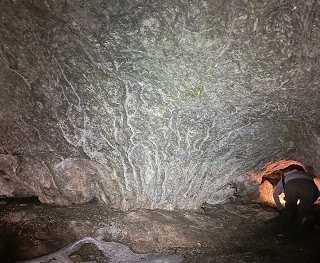

Cave bacon next to an explorer
heading into another chamber
As to the caves, they were 100% worth the drive. While we didn't explore all 13 (and no doubt more) caves, we took time to explore five or six. Most of these were large enough to stand up in. Some featured large openings, others we squeezed under low openings before we stood up. For the more adventurous, often the caves had small openings on the sides or in back that revealed narrow chambers to crawl in and explore further.


Fossil in the cave wall


Some of the caves were dry, others featured continuous dripping water from the ceiling and walls that creates tiny, calcified stalagmites, stalactites and cave bacon. 

With our headlamps, we could also explore the walls and ceilings, looking for marine fossils embedded in the limestone. At one time, this area, like ours, was undersea. Limestone holds a rich fossil record of trilobites, shells, cephalopods and receptaculites.


Baby bloodroot
Because I was 100 miles south of my stomping grounds, I was delighted to see many early wild ephemerals that are nowhere near bloom -or sprout- time here in the La Crescent area. Spring beauties (their leaves are edible!); sharplobe and roundlobe hepatica; just about bloomed Dutchman’s Breeches; and a tiny delicate bloodroot made their appearance. 

Walking Fern

I spotted purple-margined liverwort and fern moss and was also introduced to a new-to-me fern: the walking fern. My eyes were bedazzled by this young growth after so many brown months.


After the hike at a nearby taproom, some of us gathered. Laughs, conversation and many ideas for hikes in the area were shared. Thanks Taylor, Andrea, Diana, Megan, Emily and others for all the ideas.


THE HIKE

From it's start on top the prairie, this grassy, 2.5 mile loop trail descends 250 feet into a wooded valley with huge limestone walls and tumbled rocks. On each side of the wide fairly flat trail, the steep hillsides climb towards multiple caves which are open to exploration. There are a few faint paths to follow up to them. A headlamp or flashlight reveals many calcified (and growing) formations like stalactites and stalagmites as well as embedded fossils in ceilings and walls. A last short, steep hill brings you out of the woods and back to a prairie with expansive views of the countryside and back to the trailhead. 

The Location    29912 9th Avenue, Bernard, IA 
25 miles southwest of Dubuque off Hwy 151, head south on Curoe Rd. Follow the park signage until you see a last sign indicating a right turn at the entrance. Follow the gravel road to the large parking lot. There is a pit toilet available. The Lost Canyon trail is marked and begins to the south of the parking lot kiosk.

She Explores Driftless hikers

Looking for more area hikes? Please stop by the web version of the blog and under the "Labels" tab on the right hand side of the blog, click on "find-a-hike". There are over 75 hike descriptions and lists of hikes to try!
Thursday, February 27, 2025

Ice, Ice Baby! WI Driftless Ice Cave Hikes

Hiking with BLUFFLANDS hiking group at Weister Creek ice cave
Image - Steve Dawson

I recently reacquainted myself with the delightful fun of Driftless ice caves, thanks to the Blufflands Hiking groupSteve Dawson, the group’s leader, plans and scouts interesting hikes that are open to all. The ice caves of the Kickapoo Valley Reserve (KVR) at Weister Creek Rd was this month's delightful destination - plus we added an extra stop at Wildcat Mountain State Park. It was the perfect time of winter to visit - snow cover to help us follow access trails and massive ice formations at the caves.

Peeking out of the ice curtain

In the Driftless, February to mid-March are especially great times to visit the ice caves. The KVR is an incredible landscape of sandstone cliffs and steep hills that follow the meandering curve of the Kickapoo River.

Unlike the Lake Superior ice caves formed by wave action, these caves are formed by spring fed water that seeps through and percolates over the edges of the numerous sandstone cliffs in the Driftless hills and coulees, especially in Wisconsin’s Kickapoo Valley Reserve and nearby Wildcat Mountain State Park. 


Almost to the Weister Creek ice cave


Freeze and thaw cycles also add to the ice sheets and create curtains of icicles across the openings of eroded sandstone bowls. These curtains and the undercut sandstone create perfect caves. Icy pillars and other formations are also a highlight.


Inside the Wildcat Mountain SP ice cave


Hiking sticks and microspikes or ice cleats are really helpful for these hikes. The trails to some of the caves are often quite steep as you climb up or down the slopes to reach your destination. 


Stand up - carefully -  and be counted inside
the Weister Creek ice cave.      Photo - Steve Dawson

The ice cave floors are thick with ice so care is needed once inside. And care is also needed when entering caves. It’s an art to squeeze between or underneath icicles to avoid breaking them. Leaving the ice as intact as possible means hikers who come after you have the same great experience.


One pro tip, if you haven't gone before, wait until there is snow on the ground. It is MUCH easier to follow the tracks of other ice cave seekers as you make your way to the caves


THE HIKE and The Locations
In the Driftless, February to mid-March are especially great times to visit the ice caves. The KVR boasts an incredible landscape of sandstone cliffs and steep hills that follow the meandering curve of the Kickapoo River. The cave at Wildcat Mountain State Park is also a very short, easy hike for everyone.
Here are three great hikes to see the ice caves:

Wildcat State Park ice cave
Image - Julie Keitel
Kickapoo Valley Reserve Weister Creek [EASY TO CHALLENGING] - S2666 Weister Creek Rd, La Farge  43.630471, -90.650354 (south of Ontario WI on Hwy 131, off Cty Rd P west) - A short 1mile out-and back hike. From the trailhead, walk alongside farm fields (any antler shed in those standing corn fields with deer tracks everywhere among the stalks?) and the banks of Weister Creek quickly brings you to a short, forested climb up to the first ice cave. The access to the first cave is very steep but the reward is worth is. This is a long cave with enough room for a group to stand in and be completely hidden by the icicle curtain. A second, less impressive cave that is more challenging to access can be found further down the unmarked trail.
  • Kickapoo Valley Reserve Valley of the Ice [CHALLENGING]
     - 3803 Corps Rd, La Farge   43.592603, -90.640282 (from the Kickapoo Valley Reserve Visitor Center, head left on Corps Road until you get to the Stark Town Hall and Maintenance Shed and park. You should see signs directing you towards the ice caves on the West Ridge snowmobile trail to begin your hike. Watch for blue tape to guide you). This is a longer hike (about 2.5 miles) and I would rate it as difficult due to the extremely steep and slick slopes as well as significant ice spillage as ice melts and refreezes outside the caves. Once beside the snowmobile trail, you will head up a high hill with some pretty sweet views. You will cross under some power lines which will alert you to look to the right for a trail(s) down into the valley. This is challenging and pretty steep going and is NOT recommended for those who are not in great shape and strong hikers. Even then, microspikes/ice cleats and at least one hiking stick can be extremely helpful.
  • Wildcat Mountain State Park Ice Caves [EASY] - 13766 Cty Rd F, Ontario  43.688403, -90.568754 (Head through Wildcat Park and continue onto Cty Rd F to the parking lot by the ice cave sign parking lot) - This extremely short (just over .6 miles out and back) well-used trail, that starts between a flowing creek and impressive sandstone rock walls, is very easy with just a slight elevation gain making it perfect for all ages. The ice cave is fairly large and when I was recently there you could hear water dripping. There are pit toilets available near the halfway point in the trail.
I highly recommend at least one trip to explore these icy beauties. You need to purchase daily or annual passes for both the Kickapoo Valley Reserve and Wildcat Mountain State Park. I urge you do to so. So many parks and outdoor nature centers are struggling especially in recent times of funding cuts now and over the past decade or two. Our dollars can help support their missions.

You can read additional reviews of these trails at Wisconsin Explorer and Explore Southwest Wisconsin blogs.

Looking for more area hikes? Please stop by the web version of the blog and under the "Labels" tab on the right hand side of the blog, click on "find-a-hike". There are over 75 hike descriptions and lists of hikes to try!

The opening to the Weister Creek ice cave
Image - Tim Anderson

Images, unless noted - Marge Loch-Wouters

Tuesday, September 5, 2023

Cave Adventures in the Driftless

Kickapoo Cavern walls
For those in the know, southeastern MN and southwestern WI hold a wealth of cave systems - many yet undiscovered and unexplored. Others were discovered in the 19th and 20th centuries and were developed into tourist attractions. While some of these caves continue as commercial businesses, two caves I recently went through on guided tour - Mystery Cave near Preston MN and Kickapoo Caverns near Wauzeka WI - have been protected and are either offered to the public as part of the MN state park system or protected by the Mississippi Valley Conservancy (MVC) and used as research areas to help support declining bat populations.

The Driftless and Driftless-like parts of both MN and WI have a unique geology - karst.  According to the Forestville/Mystery Cave park's website,  "Karst occurs in areas of soluble rocks, usually limestone or dolomite. As rainwater percolates through the soil, it is rendered slightly acidic as it picks up carbon dioxide from microbial decay of organic soil material. This fortified water has the capacity to dissolve the rock. The effects of this dissolving action are minute from the perspective of a human’s lifetime. However, over the course of many thousands of years, dramatic changes occur; the typical features of karst develop – caves and sinkholes form; underground drainage occurs." 

The caves that formed over this time are used by bats as hibernucula from late October until early May. In the warm months in between, the caves are open for human visitors like us.

Heading deep into
Kickapoo Cavern

I was fortunate to register for the annual Mississippi Valley Conservancy Kickapoo Cavern Bat Ecology tour day in July. This is a one-day, once-a-year opportunity. The cave system is one of Wisconsin's longest natural cave systems. Once a tourist destination, the tour starts through the same door tourists used in the rustic old visitor center. The Mississippi Valley Conservancy works with the WI DNR and universities who are studying how the cave's population of bats (little brown; northern long-eared; and eastern pipistrelle) have been able to maintain their numbers despite the devastation of whitenose syndrome that has ravaged up to 90% of bat populations in other caves.

150 year old "baby" stalactites

The cave itself features "rooms" - the Register room where early explorers and tourists would write their names on the walls with graphite; the Cathedral room with 40 ft ceiling and a long straight cavern that could contain crowds; the Pipistrelle Pool room with its large, still pool. In the early days, explorers would break off stalactites and stalagmites as souvenirs so many of those lovely features are gone. Instead, we see 1"-3" "babies" forming. These babies are over 150 years old.


Calcium-rich water drops

Throughout the tour, we could hear the slow drip of droplets from rain and groundwater  around us.  The water continues it's millennial work of wearing away the limestone and dolomite to create more cracks and openings. Seeing the cave through the eyes of the bat ecologists who guided us was also a powerful learning experience. You too can take the tour through
this video made by the MVC


Old road sign displayed
in the Mystery Cave Visitor Center
On our hike to Forestville State Park  recently, we took the opportunity to tour at the park's Mystery Cave. The Mystery Cave, also once a tourist attraction, was only discovered in the late 1930s. At 13 miles of caverns, it is the longest cave so far discovered in Minnesota. It was acquired by the MN DNR in the late 1980s, modernized and his open daily for tours from May-October when the bats are gone. The modern visitor's center has great informational displays explaining the geology and bat bat population.

Pyrite revealed under
black light

Our tour took us through only about a half mile of the cave system. An interesting feature of the cave is that the ceilings are naturally smooth and almost squared off. It looks like it has been constructed. A tree root visible in a crack in the ceiling while we were 34 feet underground spoke to the living forces that help explain how persistent life is and how water and roots changes all landscapes - even caves!


The small white dots in the water above
are blind springtails under a 
cluster of botryoids

There is small and microscopic life in the cave. We were surprised to see a small pool containing tiny white dots - these are small blind springtails that live off dust - and human hair! Apparently kids love to hear that. I understand, they leave alot of food!

We had a chance to see a cephalopod fossil in the ceiling, pyrite and colored rock under black light, a large still pool, and rock formations called cave bacon that put us in mind of the "ice bacon" we saw at Vetsch park last winter. The rock formations this ribbony bacon formed on were alike in the cave and the rocks in Vetsch. Nature's patterns are strong!


Both tours gave me a ton of information that help me better understand karst geology and the role of caves as hibernacula for bats. I can't recommend this kind of learning highly enough.

Thursday, August 31, 2023

Canfield Big Spring Trail (MN) Hike

Last fall, I was intrigued to read in MN Conservation Volunteer magazine about three big spring sources to visit in southeastern MN. I had already visited two of the spring sources: Fountain Big Spring, on one of my MN Master Naturalist training field days; and Beaver Creek Big Spring in Beaver Creek Valley State Park. The third, Canfield Big Spring, looked like a great hike so a few friends and I scouted it out last fall. What a find! 

Drifters at the source of the spring
I recently shared the hike with friends in much warmer weather. Canfield Creek is located in Forestville/Mystery Caves State Park in southeastern MN near Preston. This 4 mile out-and-back hike features a mostly wide dirt and gravel road trail that winds along the south branch of the Root River and then follows Canfield Creek upstream to it's source. 

Bridge over the south branch of the Root River 
where Canfield Creek runs into it

You can begin your hike at the campground; at an "angler's parking lot," or a bit further near the group campground in non-summer times. Each trailhead leads you down a steep slope into the valley to a flat trail. Near the start, you cross a bridge spanning the Root River where the Canfield Creek joins it. From there you wind your way through hardwood forest.

Boots and packs left behind
before the first crossing


About 1/4 mile from the source of the spring, a washed out bridge gives you your first opportunity to wade across the creek in the cold 47F water. It's nice to have sandals/watershoes for this short crossing. 

The water can be anywhere from ankle to knee deep depending on your height (or higher in spring or after big rains). This is your longest crossing. Stay in that footwear because you are getting close to the source. We left our packs and boots behind at this first crossing and hiked the rest of the way in our sandals/watershoes.


Looking inside the cave at the source
Image - Cyndy Reichgelt
In just a bit, you come to a hitching post (the trail is shared with horses) and across the way is the source of the creek. You can wade out to the small cave to take a closer look at the water streaming out of the limestone cave. Above the spring, the rock walls are covered in ferns and plants, suggesting the Hanging Gardens of Babylon.

The water can be deeper in this part of the creek but still walkable, especially if you have a steadying hiking stick. We lucked out (if you can call drought lucky) with low water levels. Even with shallower water, it's hard to stay long in the bracingly cold stream. I give big props to Drifter Cyndy Reichgelt who got right into the cave for this amazing view  of the cave's interior!


Big Spring source


The creek crossings and beautiful trail make this a fun adventure. Add on a tour of Mystery Cave (also a chilly 47F) like we did and you get two great examples of how the karst geology of this part of MN results in caves, sinkholes and multiple spring sources. 

I'll  share some of our Mystery Cave experiences as well as another cave adventure in the Driftless region - and information on karst geology - in my next blog post.


THE HIKE

After a steep descent into the valley, follow a flat 2 mile trail through hardwood forests along the Root River and Canfield Creek to the creek's source, Big Spring. You need to wade two creek crossings near the end (packing sandals.watershoes are an option) with cold 47F water that can be shin-to-knee-high in depth (depending on the season) to view the source - a small cave in the second creek. The trail is shared by horses so watch your step as you hike. Turn around and return to the trailhead for a 4 mile hike. 


47F water wading
Image - Nola Larson
Location
Forestville/Mystery Cave State Park, 21071 County 118, Preston, MN 55965

There are many roads leading to this park that is southwest of St. Charles on I-90. I have tried quite a few and like them all. You will be winding about but you WILL get to Forestville State Park. All are good and take you through beautiful farm areas and near many sinkholes as you drive closer (Fountain is the "sinkhole capitol of MN"). 


At the source
Image - Nola Larson

Images, unless noted - Marge Loch-Wouters

Looking for more area hikes? Please stop by the web version of the blog and under the "Labels" tab on the right hand side of the blog, click on "find-a-hike". There are over 75 hike descriptions and lists of hikes to try!