Showing posts with label geology. Show all posts

Wednesday, May 7, 2025

Dodge County (WI) Ledge Park Trail


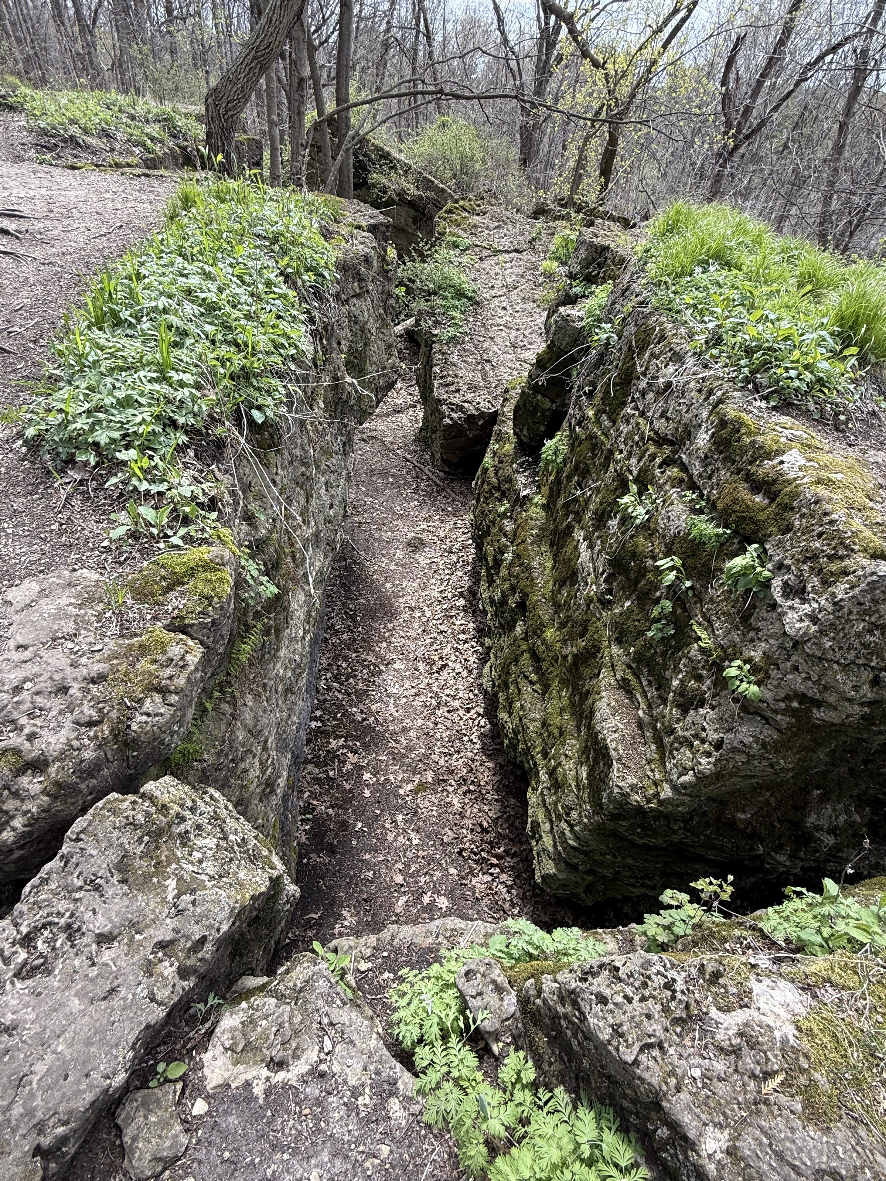
Recently, in a post on the Women Hiking WI Facebook page, I was intrigued by a wonderful gem of a hike in east central WI at a small county park between Horicon and Mayville. The video that was shared showed tumbled slabs of rocks, stairways and slots among high rock walls. Oooh.


Since I was heading to a conference in Oshkosh, I thought that exploring that spot on my way would be a perfect break before the serious business of the conference.


Ledge Park is well-named. It is part of a geological formation called the Niagara Escarpment. This arcing limestone formation originates in Canada, just under Lake Ontario curves upwards through Canada into Upper Michigan before descending through Wisconsin's Door County Peninsula before ending in the east central part of that state. While other portions of softer surrounding rock eroded over millions of years, this spine of dolomite endured to create a system of dramatic ledges.
Image - Wikipedia
This particular part of the escarpment has hiking trails on top the ledge. I chose the main trail, a one mile long trail (the red trail on this map) as my main trail. It follows along the rim but for the first half mile or so also has stone and wooden steps that lead to winding trails through a jumble of limestone slots and tumbled rocks under the rim. Pair that with an absolute riot of spring ephemerals in May and you have one of the most beautiful and fun exploratory hikes in Wisconsin.


The paths below the rim are a rock scrambler's dream. There are a few places to descend to a wonderland of narrow labyrinthian trails. They take you in and out of tight spots, climbing over boulders and through slots that lead to dead ends or narrow twisty passage. You won't put on miles but you can spend a long time playing around in the complex off the main trail.


If you ascend back up to the rim, you can hop between the tops of dolomite columns or cross a few by wooden bridges. The trail continues through the woods and behind a long series of campsites on the rim top to extraordinary views of the surrounding area including the massive Horicon marsh. 


While I was there on the last day of April, I was surrounded both on the rim and among the lower trails by carpets of Dutchman’s breeches, bellwort, wild ginger, bloodroot, sharplobed hepatica, spring beauty, trout lily, white trillium, violet, false rue anemone, bulbet bladderfern, ramp. By the time you read this, endless shooting stars will be blooming.

I can't recommend this fun spring hike enough. I thank Dineo Dowd for highlighting it and encouraging people to hike it!

THE HIKE
This 2 mile out-and-back hike runs along the rim of a dramatic ledge as well as down below the rim. The rim hike has outstanding views as you traverse some of the ledge columns. For those who like to scramble and explore, stone and wood steps lead you down below the rim to tumbled limestone rocks and slots in a series of short trails. For an added bonus, plan your hike in late April/early May and enjoy massive spring ephemeral blooms.

The Location - N7403 Park Road Horicon, WI, 43˚ 27.706’ N 88˚ 34.875’ W
Located approximately 3 miles northeast of Horicon off Raasch Hill Rd. Follow the park signs to turn onto Park Drive and then a leaft into the park. Park at the first parking lot and hit the trail! 

Trout lilies


Images, unless noted - Marge Loch -Wouters

Looking for more area hikes? Please stop by the web version of the blog and under the "Labels" tab on the right hand side of the blog, click on "find-a-hike". There are over 75 hike descriptions and lists of hikes to try!

Tuesday, November 26, 2024

Levis Trow Mounds (WI) - Levis Rim Trails

The last time I posted about Levis Mounds, we were on a short out-and back-hike of 2.5 miles with a friend who was testing a rehabbed knee on the elevation and rolling terrain. There was more to explore so I headed back to check out a few more of the amazing rim and upper bluffside trails and a different trailhead during a few 4-mile hikes up and around some of the rim's features.

There are two trailheads on this part of the recreation area to access the Levis Mound rim trails: 

The trailhead sign by the main parking lot
Image - Steve Dawson
The first is the main trailhead that has a number of amenities and a sign marking the hiking trail's start. 

This is my favorite way up by far. From this trailhead, it's a quick 20 minute or so hike up Dump and Bear Den trails. These narrow trails run through lovely forests and beside rock faces and take you quickly up to Northface trail. From Northface you can begin to explore the multiple routes.

There are also other routes from this trailhead to get up to the rim that you can can explore, especially if you want to add additional miles to your hike. Many  feature wide, grassy old logging roads. The trails are shared biking and hiking trails but on weekdays the bike traffic is light and bikers and hikers accommodating for each other.

The second trailhead is just south and around the corner on WI Hwy 95. For me, this is a slightly less interesting trailhead. The first half mile of so is through a low logged out area (with newer tree growth) quite near the highway that looks pretty rough before you finally start climbing towards the wooded hillsides of the Levis Mound.

The rock that beckoned us!
Our hike from this second trailhead took us along Warmup trail to a left on Switchback. After we wound through the first scrubbier area, we finally starting to ascend the mound with its huge hardwood forested slopes. Aaaaah. One of the first rock formations we came to begged us to scramble around on it. We spotted a small trail upwards from the rock top and, after a steep quick climb, emerged at the Troll rock at the rim. Keeping on the other trail would have made for a longer hike so we were glad we explored! 


The rim trails can be narrow and rocky but changes in elevation are fairly slight or rolling at most. Up here, there are plenty  of incredible overlooks and amazing rock formations to explore. The views at the top overlook vast forests below, as well as the slopes of Levis Mound. You can glimpse Black River Falls in the near distance and other mounds and small bluffs, part of the ancient ocean floor farther away.

Some of my favorite features besides the Troll Rock include:


South Point Overlook - South Point trail heads off Clarence to the right and leads to a huge area of rocks and stellar views.


High Rock Overlook - From Northface, take Clarence Trail to access High Rock overlook as well as a couple other unnamed overlooks along the trail.  

Plummer's Crack - From Northface trail, take Corkscrew for a hot minute to Toad Road trail and you are treated to a boardwalk between two huge rock formations. It's great fun!


Toad Road's Rock Faces - Continue along this trail and soon you will be treated to a huge stretch of towering sandstone features along the left-hand side of this upper bluffside trail. For me, this is one of the more breathtaking features of the Levis Mound hikes I did. You will once again run into Northface if you want to return to the main trailhead or for the Hwy 95 trailhead, follow Switchback to West Levis (logging road) or Select Cut (narrow woods trail) back to your start.


THE HIKE
Hardwood forests, multiple trails (that can be confusing - an app like AllTrails can be very helpful), gorgeous rock formations and overlooks that show endless forest lands are all in store on this 41 mile hiking/biking/skiing trail system. You can tailor your hiking explorations to do the mileage you prefer. Your elevation gain will be in the 380-400 foot range (the mounds are shorter than the Mississippi River bluffs). This is a great area to visit multiple times. Once up on the rim, there are multiple trails and rock formations to explore in any season.

The Locations: 
The trailheads are located just about 17 miles out of Black River Falls. There are groomed ski trails in the winter. Bikers and skiers pay a small usage fee; hikers can use the trails for free.
  • Main Trailhead: N1589 Fisher Ave, Neilsville WI   44.47676, -90.72377 (bathrooms/shower/campsites/covered picnic area)
  • Hwy 95 trailhead: from Black River Falls, take a right on Hwy 95  44.46646N, 90.72404W.  (pit toilet) 


All images, unless noted - Marge Loch-Wouters


Additional posts describing Levis Trow Mounds Recreation Area trails:

Looking for more area hikes? Please stop by the web version of the blog and under the "Labels" tab on the right hand side of the blog, click on "find-a-hike". There are over 75 hike descriptions and lists of hikes to try!


Tuesday, October 29, 2024

Levis Trow Mounds (WI) - Troll Rock Trail

Looking thru a "keyhole formed
by massive sandstone.
Image - Lavon Court 
Well, at least I call the trail that. If I used the various segments we hiked, it would be called “ Pine Run/Upper Glen/Pine Run/West Levis/Jackrabbit Draw/North Face/Dump/Pine Run" and out! 

Somehow Troll Rock Trail seems lots simpler and recognizes the interesting geological sandstone features that looks like the bottom half of a monster troll (or two rocks kissing; this feature is also known as Kissing Rocks) - our turnaround for this out-and-back hike.

Levis Trow Mound Recreation Area near Black River Falls is a huge network of hiking, biking, skiing and snowshoeing trails that cover the mounds and hills near the end of the glaciated land that butts up against the Driftless area. These geological features, called nunataks, are said to have stood above the ice sheets and were shaped by them. 


The number of trails is truly impressive - and can be confounding until you get familiar with them. I am still in the confounded stage but I am drawn to the beautiful woods, hills and rocks here so expect I will get to know them better.

The trails vary from wide, former roads on grass to narrow dirt and rocks trails that hug the cliffsides. There are plenty of elevation changes up and down as you head towards the rim on this set of trails but nothing a pause and a quick drink or snack can’t fix!

This series of trails takes you around the rolling mound trails s and then up to the rim for some great views of the surrounding lowlands. 

Peeking around the "troll's legs"
Image -Nola Larson


On this particular hike, my goal was a group of massive sandstone rocks near the top that remind me of the legs of a troll. It is off a small spur on North Face. Dropping down a short, steep incline brings you to a lovely, flattish, pine needle-covered area with a number of large rocks that are great fun to explore. 

On this trip, we kept our mileage low because of time constraints but still enjoyed a great colorful fall hiking experience in a unique area. And as always we promised ourselves we'd be back to explore more!


A peek through the pines
THE HIKE

This is a moderate hike on rolling shared bike trails through interesting forested geological mounds. This 3.6 mile hike had a total elevation gain of 341 feet reaching our highest elevation at 1200 feet. There are multiple trails criss-crossing each other so an app map can be VERY helpful. The trails are well maintained, alternating between wide grass former roads/ narrow forest trails.

The Location: 
N1589 Fisher Ave, Neilsville WI   44.47676, -90.72377
The trailhead is located just about 17 miles out of Black River Falls. It features a large parking lot and building with bathrooms and a covered picnic area. Campsites are available as well. There are groomed ski trails in the winter. Bikers and skiers pay a small usage fee; hikers can use the trails for free.


All images, unless noted - Marge Loch-Wouters

Additional posts describing Levis Trow Mounds Recreation Area trails:

Looking for more area hikes? Please stop by the web version of the blog and under the "Labels" tab on the right hand side of the blog, click on "find-a-hike". There are over 75 hike descriptions and lists of hikes to try!

Friday, October 20, 2023

Hiking the Drifted - North Shore/BWCAW

Over the past four weeks, I twice found myself up on Minnesota's North Shore for hiking and paddling adventures lasting a week each. I always enjoy hiking areas with different geological characteristics. And much like hiking in the southwestern US, the North Shore has a ton of great geology and challenging hikes thanks to glaciers and the pyrotechnics of the land's formation.

The first week was primarily a paddling vacation with my canoeing buddies into the Boundary Waters Canoe Area Wilderness (BWCAW) out of Ely, MN. I was testing out my shoulder after a year-long rehab to see if 6 hour paddles and portaging our Wenonah canoe were still in my toolbox. Mission accomplished - they are. 

Can still portage and paddle!

The second week, my honey and I headquartered near Grand Marais for hikes and leaf-peeping in the Superior National Forest along the Gunflint Trail, in the Sawtooth Mountains and along Hwy 61.

I had plenty of great hiking adventures throughout those two weeks. These trails feature sharp, steep inclines and winding, twisting and often-tree-root-ridden trails. The evidence of the imperviousness of Canadian Shield rock screams at you as you tackle these trails. Finding "easy" or flat trails is a completely different venture than in the Driftless area. I find this hiking good for the soul and soles.

My hikes included:

Eighteen Lake

Eighteen Lake,
Superior National Forest, Tofte District

Located near Isabella, MN off Hwy 1

This 2.9 mile hikes closely follows the shore of a small lake located in the Superior National Forest. Wetlands, hardwood forests, pines, small creeks and a few steep climbs to outlooks are all rolled up in this hike. The trail is clear although a bit overgrown in low-lying areas. The two or three steep climbs are primarily in the section to the right of the small (4 sites) rustic campground. The views are so worth it! I would rate this as moderate due to overgrowth on many parts of the trail and extremely steep hills to the outlook.

Dry Lake Trail
Dry Lake Trail,  Superior National Forest, Kawishiwi District

Located near Ely MN off Hwy 116

This is a loop trail but we decided to do an out-and-back after talking to hikers who said the northwest section of the loop was very difficult due to so many large rocks and exposed roots. We hiked 2.5 miles from the Basswood Lake trailhead and back. The trail is rolling and twisty with a number of outlooks along the way that give dramatic views of Basswood Lake. There is a small waterfall that was very dry this time of year but it was definitely a fun if challenging hike with elevation gains of 275 feet. I would rate this as moderate.


View from Wolf Rock
Wolf Rock, Superior Hiking Trail, Castle Danger to Gooseberry Segment

Located near Castle Danger, on Hwy 106, off Hwy 61

While this trail segment of the SHT heads approximately 9 miles to Gooseberry Falls, we were most interested in the very first half-mile section that leads to Wolf Rock. For a quick but steep hike, the reward is expansive views of Superior National Forest, Crow Creek Valley, Lake Superior and the Sawtooth Mountains. Not bad for a mile out-and-back!  Like almost all SHT segments, the trail up and down is seriously serious - but once up on the ridge the hike is easy - and those views!

My new fascination -
rockcap ferns at Topper Lake portage
Topper Lake Portage, BWCAW, Superior National Forest, Gunflint District

Off the Gunflint Trail, Forest Rd 317 (Mayhew Lk Rd)

A small sweet trail (especially sweet without a canoe to portage!) through wetlands and mixed forest features a huge boulder strewn area with ferns, lichen and moss growing everywhere. Less than a mile but a great stretch when driving up the trail to the Chik-Wauk Museum at the end or the Trail Center restaurant in the middle of the Gunflint Trail for the best malts and shakes around.


Divide Lake

Divide Lake Trail
, Superior National Forest, Tofte District

Near Isabella MN, off 600 Rd.

Tucked deeply into the forest, this beautiful canoe lake straddles the Laurentian Divide. On one side of the Divide, the waters drain to Lake Superior; on the other, the waters drain to Hudson Bay (Divide Lake's waters drain to Superior). This 2.7 mile hike was probably the flattest of all these hikes. It meandered around the larger lake on the east side of the road. The trailhead is at the 3-site rustic campground. There are a number of benches along the trail that winds gently up and down through hardwood and pine forests. There is a backpack site to peek at on a spur off the trail. 


Temperance River Loop
Image - Lloyd Lorenz

Temperance River Loop
, Temperance State Park

Near Silver Bay on Hwy 61

A popular hike is best done on a cool early morning with rain threatening. It guarantees few to no people on the whole trail! This 2.5 mile hike starts dramatically following the falls and gorges of the Temperance River as you climb and clamber up rocks and rock stairs to a multitude of stone-fenced lookouts along the first 1/4 mile of the trail. The Gitchi-Gami bike path crosses the trail at the bridge. From there you continue to ascend as the river slows. Continuing on this 2.7 mile loop, you once more climb steeply to another set of falls (more difficult to see) before turning and heading through gorgeous hardwood forest to rejoin the gorge trail for the final quarter mile back to the trailhead. The iconic stone fences and amazing views and the seldom-hiked back part of the loop keeps this hike as one our favorite of the massively used state park trails on the North Shore.

All images, unless noted - Marge Loch-Wouters


Tuesday, October 10, 2023

Reno Quarry (MN) Hike

The south view from the top
Located in Minnesota's Richard J. Dorer Memorial Hardwood State Forest in the Reno Recreation area, this easily-accessed, short set of trails results in some spectacular river and bluff views and unique rock formations. 

The trailhead is near the top of the bluff about a mile off MN Hwy 26. As you head up to it, you pass a few homes and then enter the forest. There is a campground to the left but just keep heading up the road until just before a sharp left-hand bend in the road, you spot a gate with a small parking lot to the left of it. 


Fire ring and "Flintstone 
Furniture" on quarry floor
The trail begins by the gate. Head north along the old-logging road and you soon make a sharp turn (south) to the right and begin a steady ascent up to the quarry itself. The woods along this first part of the trail are alive with wild flowers and ferns through most of the growing season. Along the way on your left, you will begin to see sharp drop-offs on private land and the beginnings of the rock face of the bluff as well. 

Soon you emerge into the quarry itself.  It is a well-used area with "Flintstone furniture," a large homemade fire ring, some graffiti and some trash (I try to come prepared with a small trash bag). There are some small, steep spur trails here and there to access the rock wall, although I didn't take the time or risk to explore them much. There is plenty of room to wander and explore on the flat stone quarry floor.

The north view at top of quarry

If you continue upward on the main trail for a few more hundred feet and turn left, you end up at the top of the quarry itself with a spectacular view of the bluffs and Mississippi River to the north. The trail ends here at a fence to prevent access to the quarry top.


The money view though, in my opinion, is still to come. Head back down towards the trail but go straight rather than turn right. You quickly emerge onto a point in a goat prairie remnant with expansive views of the Mississippi River, the Reno Spillway and its floodplain forests, Wisconsin river bluffs and MN bluffs. During spring and fall waterfowl migration, it's not unusual to have swans and geese flying just over your head on their migration routes. The rocks and grass provide ample seating to give you time to soak up the incredible views.

Enjoying the views on the outlook - including swans migrating


Atop the "spinal column" rocks
Once you turn around and head back down again, you come to an intersection (where you originally turned to your right). Follow the trail north and then up towards the river. There you will find a unique rock formation that, from a distance, might remind you of a human spinal column. Made up of alternating layers of limestone and sandstone, these columns again afford a panoramic view of the river and WI bluffs. You can easily scramble to the top of these columns to soak up the views. Fifty feet or so down the trail from these, you can get great camera shots of people standing on these unique flat-topped columns.

You can follow the trail slightly further north where it descends down into the woods and bushwhack back through the woods on the faintly outlined old logging/quarry road or head back directly from the outlook on the established trail.

These trails aren't regularly maintained so summer hiking is pretty overgrown and there are deadfalls to go around or over in all seasons. Spring and fall when growth is new or dying back are ideal. This is a hunting area so be aware of MN hunting seasons and wear blaze colors as you hike.

THE HIKE

My favorite rocks on my favorite hike
Image - Lloyd Lorenz
This 2.5 mile hike has about a 250 foot elevation gain. It starts high up on the bluff so the views of the river, bluffs and rock formations make it a hike that even older kids can do. The first part of the hike up to the quarry and higher outlooks is the steepest. The trail down to the "spinal column" rocks is fairly level and great for a short amble - definitely more family-friendly as well. The trails tend to be overgrown during the summer so spring and fall when vegetation has died back or is just emerging is ideal. It's also the best time to try to catch swan and geese migration on the wing  (early mornings and evenings).

Location

Heading south from La Crescent, take Hwy 26 about 20 miles or so until you see a sign for "Reno Recreation Area" on your right. Turn right at Hillside Dr and follow that about a mile up the road until you see a gate with a small 3-4 car parking lot ringed by stones to the left of the gate (before a sharp left-hand bend in the road). The trailhead begins behind the gate.

Unless noted, all images - Marge Loch-Wouters

Looking for more area hikes? Please stop by the web version of the blog and under the "Labels" tab on the right hand side of the blog, click on "find-a-hike". There are over 75 hike descriptions and lists of hikes to try!

Tuesday, September 12, 2023

Levis/Trow Mound Recreation Area (WI) Hike

A "peek-a-view" near the top
If it's high, rolling bluff-like hills under shaded pines with a great variety of massive rock formations that you want, this 41-mile trail system for non-motorized use near Neillsville is a hiker's paradise. 

Levis/Trow Mounds is a unique geologic feature contained in one portion of the 185,000 acre Clark County Forest in west-central Wisconsin.  The mounds, referred to as nunataks, are believed to be "islands" that rose above the last glacier that covered Wisconsin 10,000 years ago. The mounds are also part of the terminal moraine of the final glacier before entering Wisconsin's Driftless area. As such, the 1200 foot mounds rise startlingly and tower over the surrounding area. Outlooks along the rim trails and and peek-a-views on the way up provide stunning views of part of the landscape at the beginning of the Driftless.

Blufflands hikers
Image - Steve Dawson

I joined a hike organized by the Blufflands Hiking group* in the Driftless area recently to explore part of the trails. This warm and friendly group of hikers meet up for hikes at various times of the year and have some great adventures. When I read about this trip, I jumped at the chance to discover and explore a small part of the planned 9-10 mile hike with them.


Plenty of rock formations
along the trail

The trails are shared bike/hike trails. The beginning areas of many of the trails use old logging roads. From these grassy roads, multiple narrow hiking trails branch off to climb to the rim or follow the rolling sides of the mounds. The trails feature dirt, grass, sand, rocks and roots as you work your way up and down.

Mixed pine and hardwood forests shade the trails - a must on our hiking day where temperatures were predicted to soar into the high 90s. The scent of pine is ever-present. Some trails are covered in pine needles which suggests caution on steeper parts of the trail. 


Heading through Plummer's Crack

A good trail map app is your best friend (if you are not with a group) on a trail like this with multiple intersections and slightly confusing signage on the trails. Don't rely on the provided paper maps. The good news is that the trail segments intersect at enough points that you can figure out how to link up to trails that will also take you to points you want to see or quickly down and off the trail (like I did for a 5 mile hike!)

Once near the top, you sneak peeks at the views and start to see amazing rock features to explore along trail spurs. Our group commented on how little graffiti we saw, a welcome change. We also had great breezes at the top which helped during our hot-day hike.

More fab rock formations

I only explored a small segment of the possibilities on these well-maintained trails while the group completed their 9 mile trek. This trail system is one I'll be back to so I can discover more that it has to offer. Just 36 more miles to go to finish the whole trail system!

THE HIKE

Various trail choices lead you up to the rim to gorgeous outlooks and rock formations. Trails also hug the sides of these mounds and provide great shade for hiking. Bikers we encountered were polite and gladly shared the trails (and vice versa). Hiking stick(s) can help on steeper trails. In general, I would rate this as a moderate with some easy sections and some sections that may be more challenging. The parking area is large with camping sites, picnic tables and restrooms available. Cross country-skiing and snowshoeing are available in winter as well. There is no trail fee for hiking but donations are welcome to help with trail maintenance.

Location: N1589 Fisher Ave, Neillsville, WI

From Black River Falls, head north on 12; turn right on Cty Rd E; turn left at Cty Rd K; then a quick right turn onto Cty Rd J. The parking lot is to your left and marked with a large brown sign to Levis Mounds Recreation Area.

*From their Facebook page: "BLUFFLANDS Hiking Group is a local group to the Coulee Region of Wisconsin. Our purpose is to bring people together to enjoy God's outdoors primarily through hiking. We are a Christian BASED group but not exclusive at all. We may or may not pray before hikes. The real point is, we're here to hike and meet some great people while doing so. Please share ideas for trails, hiking tips, gear, hiking reports, pictures, and more."


Images, unless noted - Marge Loch-Wouters

Additional posts describing Levis Trow Mounds Recreation Area trails:
Looking for more area hikes? Please stop by the web version of the blog and under the "Labels" tab on the right hand side of the blog, click on "find-a-hike". There are over 75 hike descriptions and lists of hikes to try!

Tuesday, September 5, 2023

Cave Adventures in the Driftless

Kickapoo Cavern walls
For those in the know, southeastern MN and southwestern WI hold a wealth of cave systems - many yet undiscovered and unexplored. Others were discovered in the 19th and 20th centuries and were developed into tourist attractions. While some of these caves continue as commercial businesses, two caves I recently went through on guided tour - Mystery Cave near Preston MN and Kickapoo Caverns near Wauzeka WI - have been protected and are either offered to the public as part of the MN state park system or protected by the Mississippi Valley Conservancy (MVC) and used as research areas to help support declining bat populations.

The Driftless and Driftless-like parts of both MN and WI have a unique geology - karst.  According to the Forestville/Mystery Cave park's website,  "Karst occurs in areas of soluble rocks, usually limestone or dolomite. As rainwater percolates through the soil, it is rendered slightly acidic as it picks up carbon dioxide from microbial decay of organic soil material. This fortified water has the capacity to dissolve the rock. The effects of this dissolving action are minute from the perspective of a human’s lifetime. However, over the course of many thousands of years, dramatic changes occur; the typical features of karst develop – caves and sinkholes form; underground drainage occurs." 

The caves that formed over this time are used by bats as hibernucula from late October until early May. In the warm months in between, the caves are open for human visitors like us.

Heading deep into
Kickapoo Cavern

I was fortunate to register for the annual Mississippi Valley Conservancy Kickapoo Cavern Bat Ecology tour day in July. This is a one-day, once-a-year opportunity. The cave system is one of Wisconsin's longest natural cave systems. Once a tourist destination, the tour starts through the same door tourists used in the rustic old visitor center. The Mississippi Valley Conservancy works with the WI DNR and universities who are studying how the cave's population of bats (little brown; northern long-eared; and eastern pipistrelle) have been able to maintain their numbers despite the devastation of whitenose syndrome that has ravaged up to 90% of bat populations in other caves.

150 year old "baby" stalactites

The cave itself features "rooms" - the Register room where early explorers and tourists would write their names on the walls with graphite; the Cathedral room with 40 ft ceiling and a long straight cavern that could contain crowds; the Pipistrelle Pool room with its large, still pool. In the early days, explorers would break off stalactites and stalagmites as souvenirs so many of those lovely features are gone. Instead, we see 1"-3" "babies" forming. These babies are over 150 years old.


Calcium-rich water drops

Throughout the tour, we could hear the slow drip of droplets from rain and groundwater  around us.  The water continues it's millennial work of wearing away the limestone and dolomite to create more cracks and openings. Seeing the cave through the eyes of the bat ecologists who guided us was also a powerful learning experience. You too can take the tour through
this video made by the MVC


Old road sign displayed
in the Mystery Cave Visitor Center
On our hike to Forestville State Park  recently, we took the opportunity to tour at the park's Mystery Cave. The Mystery Cave, also once a tourist attraction, was only discovered in the late 1930s. At 13 miles of caverns, it is the longest cave so far discovered in Minnesota. It was acquired by the MN DNR in the late 1980s, modernized and his open daily for tours from May-October when the bats are gone. The modern visitor's center has great informational displays explaining the geology and bat bat population.

Pyrite revealed under
black light

Our tour took us through only about a half mile of the cave system. An interesting feature of the cave is that the ceilings are naturally smooth and almost squared off. It looks like it has been constructed. A tree root visible in a crack in the ceiling while we were 34 feet underground spoke to the living forces that help explain how persistent life is and how water and roots changes all landscapes - even caves!


The small white dots in the water above
are blind springtails under a 
cluster of botryoids

There is small and microscopic life in the cave. We were surprised to see a small pool containing tiny white dots - these are small blind springtails that live off dust - and human hair! Apparently kids love to hear that. I understand, they leave alot of food!

We had a chance to see a cephalopod fossil in the ceiling, pyrite and colored rock under black light, a large still pool, and rock formations called cave bacon that put us in mind of the "ice bacon" we saw at Vetsch park last winter. The rock formations this ribbony bacon formed on were alike in the cave and the rocks in Vetsch. Nature's patterns are strong!


Both tours gave me a ton of information that help me better understand karst geology and the role of caves as hibernacula for bats. I can't recommend this kind of learning highly enough.

Monday, July 31, 2023

Where IS the Driftless?!?!

The "driftless" is a rare unglaciated area primarily located in west central and southwestern Wisconsin along the east side of the Mississippi River and just kissing northwestern Illinois. While both southeastern Minnesota and northeastern Iowa seem to share the same characteristics of the Driftless, they are actually not part of the unglaciated area and are outside the actual Driftless area.

From Wisconsin Geological and Natural History Survey. The Driftless Area. Educational Series 057.
Carson, E. C., Curry, B.B., Kerr, P.J. Lusardi, B.A.  University of WI Madison, 2023.

That can sometimes be hard for people to wrap their heads around. The area is a special gem of steep bluffs towering over the Mississippi River and a winding network of long valleys, bluffs and steep hills continuing outward from the river that create a magnificent landscape. It is a challenging environment in which to build, farm and recreate in. We all want to claim it as our own and have a fierce love of this landscape.

Alot of areas in southeastern Minnesota and northeastern Iowa across the Mississippi River sure look like the Driftless area to the west in Wisconsin and Illinois. There is a tendency - which even I have shared - to claim these nearby areas as part of the Driftless. But they actually experienced glaciation during the Pre-Illinoian Glaciation era (500K-2,600K ago). These areas don't display the lack of glacial sediment or "drift," as it was called in the mid-19th century, that the Driftless does.

A just-published pamphlet "that describes and outlines the boundary of the unglaciated Driftless area based on modern geologic evidence" breaks down the differences in easily understood language. Titled The Driftless Area: The Extent of unglaciated and simitar terrains in Wisconsin, Illinois, Iowa and Minnesota, and authored by members of each states' geological survey team, this brief pamphlet (2 pages of text and 2 pages of citations!) is a perfect short explanation of what is the Driftless area - and what isn't.

Because the Driftless area in Wisconsin and Illinois never experienced glaciers, it is truly "the Driftless."  The rugged landscape of bluffs, steep hillsides and coulees displays no evidence of glaciation. Rather the landscape was formed by rivers cutting down through the sediment and forming deep valleys. 

In surrounding areas in portions of southeastern Minnesota and northeastern Iowa, there is clear evidence that the Pre-Illionoian glaciation left glacial landforms and sediment.  However, because they are Mississippi River-adjacent, they were also steeply cut into by rivers and so they are topographically similar to the Driftless.

The four-state geological survey team suggest that it would be more accurate to say these areas display "Driftless-style topography." They are not truly Driftless.

From Wisconsin Geological and Natural History Survey. The Driftless Area. Educational Series 057.
Carson, E. C., Curry, B.B., Kerr, P.J. Lusardi, B.A.  University of WI Madison, 2023.

I'm perfectly good with being Driftless-adjacent in Minnesota. I'll be keeping the blog title as is but I'll be going back and adding a "Driftless area" tag to all blog posts of hikes that are truly in the Driftless. I also edited the blog's header slightly to reflect more accurately the distinction.

The more we know, the more we grow!  I love how scientific knowledge keeps evolving as research and knowledge is continually added to. It helps us to better know the world around us even as it refines - and sometimes - shakes up our understanding.